
Radnor Lake State Natural Area topographic map
Interactive map
Click on the map to display elevation.
About this map
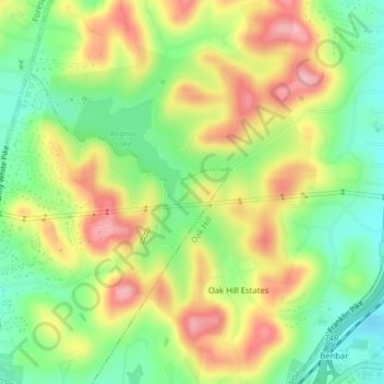
Name: Radnor Lake State Natural Area topographic map, elevation, terrain.
Average elevation: 869 ft
Minimum elevation: 646 ft
Maximum elevation: 1,129 ft
Other topographic maps
Click on a map to view its topography, its elevation and its terrain.
Colewood Acres
United States > Tennessee > Davidson County > Nashville-Davidson
Average elevation: 604 ft
Sevier Park
United States > Tennessee > Davidson County > Nashville-Davidson
Average elevation: 568 ft
Little Creek
United States > Tennessee > Davidson County > Nashville-Davidson
Average elevation: 636 ft
Green Hills
United States > Tennessee > Davidson County > Nashville-Davidson
Average elevation: 610 ft
Lockeland Springs Park
United States > Tennessee > Davidson County > Nashville-Davidson
Average elevation: 489 ft
Cherry Hills
United States > Tennessee > Davidson County > Nashville-Davidson
Average elevation: 545 ft
Town Park Estates
United States > Tennessee > Davidson County > Nashville-Davidson
Average elevation: 571 ft
Hermitage Island
United States > Tennessee > Davidson County > Nashville-Davidson
Average elevation: 515 ft
Antioch Park
United States > Tennessee > Davidson County > Nashville-Davidson > Antioch
Average elevation: 568 ft
Old Hickory
United States > Tennessee > Davidson County > Nashville-Davidson
Average elevation: 463 ft
Rock Island
United States > Tennessee > Davidson County > Nashville-Davidson
Average elevation: 505 ft
Lake Wautaga
United States > Tennessee > Davidson County > Nashville-Davidson
Average elevation: 551 ft
Tulip Grove
United States > Tennessee > Davidson County > Nashville-Davidson
Average elevation: 512 ft
Whites Creek
United States > Tennessee > Davidson County > Nashville-Davidson
Average elevation: 469 ft
Harpeth River
United States > Tennessee > Davidson County > Nashville-Davidson
Average elevation: 646 ft
Bordeaux Hills
United States > Tennessee > Davidson County > Nashville-Davidson
Average elevation: 449 ft
Brooklyn Heights
United States > Tennessee > Davidson County > Nashville-Davidson
Average elevation: 489 ft
Myrtlewood Estates
United States > Tennessee > Davidson County > Nashville-Davidson
Average elevation: 676 ft
Edge-O-Lake Estates
United States > Tennessee > Davidson County > Nashville-Davidson
Average elevation: 574 ft
Vaughns Gap
United States > Tennessee > Davidson County > Nashville-Davidson > Vaughns Gap
Average elevation: 722 ft