
Newport Beach topographic map
Interactive map
Click on the map to display elevation.
Newport Beach
Newport Beach, located in Orange County, California, features a dynamic and varied topography shaped by its coastal position and surrounding hills. The city spans from sea level along its beaches to elevations of over 1,100 feet (335 meters) in the nearby San Joaquin Hills. These hills, particularly noticeable in the southern and eastern parts of the city, create a varied landscape of steep slopes and ridgelines. The terrain transitions from low-lying areas near the coast, which are primarily flat and ideal for the city's iconic beaches, to more rugged and elevated terrain inland. The topography also includes the sprawling Crystal Cove State Park, characterized by rolling hills and canyons, enhancing both the natural beauty and the challenges of urban planning in the region.
About this map
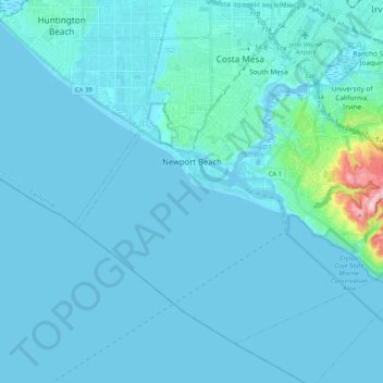
Name: Newport Beach topographic map, elevation, terrain.
Location: Newport Beach, Orange County, California, United States (33.53488 -117.99118 33.67175 -117.78390)
Average elevation: 46 ft
Minimum elevation: -13 ft
Maximum elevation: 758 ft
Orange County trails, hiking, mountain biking, running and outdoor activities
Other topographic maps
Click on a map to view its topography, its elevation and its terrain.
San Joaquin Hills
United States > California > Orange County > Newport Beach
Average elevation: 502 ft
San Joaquin Hills
United States > California > Orange County > Newport Beach
Average elevation: 502 ft
Newport Beach
United States > California > Orange County > Newport Beach > Newport Beach
Newport Beach extends in elevation from sea level to the 1,161 ft (354 m) summit of Signal Peak in the San Joaquin Hills, but the official elevation is 25 ft (7.6 m) above sea level at a location of 33°37′0″N 117°53′51″W / 33.61667°N 117.89750°W / 33.61667; -117.89750 (33.616671, −117.897604).
Average elevation: 30 ft
Huntington Beach
United States > California > Orange County > Huntington Beach
Average elevation: 52 ft