
Ladera Ranch topographic map
Click on the map to display elevation.
About this map
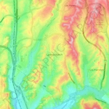
Name: Ladera Ranch topographic map, elevation, terrain.
Average elevation: 472 ft
Minimum elevation: 121 ft
Maximum elevation: 938 ft
Orange County trails, hiking, mountain biking, running and outdoor activities
Other topographic maps
Click on a map to view its topography, its elevation and its terrain.
Newport Beach
United States > California > Orange County
Newport Beach, located in Orange County, California, features a dynamic and varied topography shaped by its coastal position and surrounding hills. The city spans from sea level along its beaches to elevations of over 1,100 feet (335 meters) in the nearby San Joaquin Hills. These hills, particularly noticeable…
Average elevation: 46 ft
Laguna Beach
United States > California > Orange County
The land in and around Laguna Beach rises quickly from the shoreline into the hills and canyons of the San Joaquin Hills. The town's highest point, at an elevation of 1,007 feet (307 m), is Temple Hill in the Top of the World neighborhood. Because of its hilly topography and surrounding parklands, few roads…
Average elevation: 203 ft
Mission Viejo
United States > California > Orange County
A very short portion of California State Route 73 travels within Mission Viejo's city limits. There is a Mission Viejo population and elevation road sign directly beneath the northbound onramp that roughly marks the official city limits which travels down the center of Via Escolar to the rail tracks on either…
Average elevation: 587 ft
Fullerton
United States > California > Orange County
Fullerton is located at 33°52′48″N 117°55′43″W / 33.88000°N 117.92861°W / 33.88000; -117.92861 (33.879914, -117.928749). It is approximately 25 miles (40 km) southeast of downtown Los Angeles, and approximately 11 miles (18 km) north-northwest of Santa Ana, the county seat. The city has a…
Average elevation: 259 ft
Laguna Niguel
United States > California > Orange County
Laguna Niguel consists of mostly hilly terrain, being located within the San Joaquin Hills. The average elevation is 400 feet (120 m); elevations range from near sea level to 936 feet (285 m) at the summit of Niguel Hill, in the southwest corner of the city. Neighboring cities are Aliso Viejo and Laguna Hills…
Average elevation: 361 ft
Thousand Steps Beach
United States > California > Orange County > Laguna Beach > South Laguna
Average elevation: 207 ft
Santa Ana
United States > California > Orange County
Santa Ana is nested on flat, low-lying plains with little land elevation change. Running through the west end of the city is the mostly channelized Santa Ana River, which is also largely seasonal due to the construction of the Prado Dam and Seven Oaks Dam. The river caused several severe floods in the 20th…
Average elevation: 98 ft
Laguna Niguel Lake
United States > California > Orange County > Laguna Niguel
Average elevation: 318 ft
Santa Ana
United States > California > Orange County
Santa Ana is nested on flat, low-lying plains with little land elevation change. Running through the west end of the city is the mostly channelized Santa Ana River, which is also largely seasonal due to the construction of the Prado Dam and Seven Oaks Dam. The river has caused several severe floods in the 20th…
Average elevation: 98 ft
Laguna Beach
United States > California > Orange County
The land in and around Laguna Beach rises quickly from the shoreline into the hills and canyons of the San Joaquin Hills. The town's highest point, at an elevation of 1,007 feet (307 m), is Temple Hill in the Top of the World neighborhood. Because of its hilly topography and surrounding parklands, few roads…
Average elevation: 203 ft
Fullerton
United States > California > Orange County
Fullerton is located at 33°52′48″N 117°55′43″W / 33.88000°N 117.92861°W / 33.88000; -117.92861 (33.879914, -117.928749). It is approximately 25 miles (40 km) southeast of downtown Los Angeles, and approximately 11 miles (18 km) north-northwest of Santa Ana, the county seat. The city has a…
Average elevation: 259 ft
Mission Viejo
United States > California > Orange County
A very short portion of California State Route 73 travels within Mission Viejo's city limits. There is a Mission Viejo population and elevation road sign directly beneath the northbound onramp that roughly marks the official city limits which travels down the center of Via Escolar to the rail tracks on either…
Average elevation: 587 ft
Laguna Niguel
United States > California > Orange County
Laguna Niguel consists of mostly hilly terrain, being located within the San Joaquin Hills. The average elevation is 400 feet (120 m); elevations range from near sea level to 936 feet (285 m) at the summit of Niguel Hill, in the southwest corner of the city. Neighboring cities are Aliso Viejo and Laguna Hills…
Average elevation: 361 ft
Mission Viejo
United States > California > Orange County
A very short portion of California State Route 73 travels within Mission Viejo's city limits. There is a Mission Viejo population and elevation road sign directly beneath the northbound onramp that roughly marks the official city limits which travels down the center of Via Escolar to the rail tracks on either…
Average elevation: 587 ft
Newport Beach
United States > California > Orange County
Newport Beach extends in elevation from sea level to the 1161 ft (354 m.) summit of Signal Peak in the San Joaquin Hills, but the official elevation is 25 feet (8 m) above sea level at a location of 33°37′0″N 117°53′51″W / 33.61667°N 117.89750°W / 33.61667; -117.89750 (33.616671, −117.897604).
Average elevation: 46 ft
Newport Beach
United States > California > Orange County
Newport Beach extends in elevation from sea level to the 1,161 ft (354 m) summit of Signal Peak in the San Joaquin Hills, but the official elevation is 25 ft (7.6 m) above sea level at a location of 33°37′0″N 117°53′51″W / 33.61667°N 117.89750°W / 33.61667; -117.89750 (33.616671, −117.897604).
Average elevation: 46 ft
Laguna Beach
United States > California > Orange County
The land in and around Laguna Beach rises quickly from the shoreline into the hills and canyons of the San Joaquin Hills. The town's highest point, at an elevation of 1,007 feet (307 m), is Temple Hill in the Top of the World neighborhood. Because of its hilly topography and surrounding parklands, few roads…
Average elevation: 203 ft
Newport Beach
United States > California > Orange County
Newport Beach extends in elevation from sea level to the 1,161 ft (354 m) summit of Signal Peak in the San Joaquin Hills, but the official elevation is 25 ft (7.6 m) above sea level at a location of 33°37′0″N 117°53′51″W / 33.61667°N 117.89750°W / 33.61667; -117.89750 (33.616671, −117.897604).
Average elevation: 46 ft