
Make a donation
Gear up for your next adventure:
As an Amazon Associate, this site earns from qualifying purchases at no extra cost to you.
Norwell topographic map
Click on the map to display elevation.
Make a donation
Gear up for your next adventure:
As an Amazon Associate, this site earns from qualifying purchases at no extra cost to you.
About this map
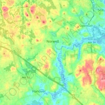
Name: Norwell topographic map, elevation, terrain.
Average elevation: 98 ft
Minimum elevation: -7 ft
Maximum elevation: 256 ft
Plymouth County trails, hiking, mountain biking, running and outdoor activities
Make a donation
Gear up for your next adventure:
As an Amazon Associate, this site earns from qualifying purchases at no extra cost to you.
Other topographic maps
Click on a map to view its topography, its elevation and its terrain.
Make a donation
Gear up for your next adventure:
As an Amazon Associate, this site earns from qualifying purchases at no extra cost to you.
Surfside Beach
United States > Massachusetts > Plymouth County > Plymouth > Vallersville
Average elevation: 30 ft
Silver Lake
United States > Massachusetts > Plymouth County > Pembroke > Oakland Square
Average elevation: 75 ft
Make a donation
Gear up for your next adventure:
As an Amazon Associate, this site earns from qualifying purchases at no extra cost to you.
South Middleboro
United States > Massachusetts > Plymouth County > Middleborough
Average elevation: 112 ft
Make a donation
Gear up for your next adventure:
As an Amazon Associate, this site earns from qualifying purchases at no extra cost to you.
George Washington Forest
United States > Massachusetts > Plymouth County > Hingham > South Hingham
Average elevation: 121 ft
Marshfield Hills
United States > Massachusetts > Plymouth County > Marshfield
Average elevation: 95 ft
Make a donation
Gear up for your next adventure:
As an Amazon Associate, this site earns from qualifying purchases at no extra cost to you.
Make a donation
Gear up for your next adventure:
As an Amazon Associate, this site earns from qualifying purchases at no extra cost to you.
Make a donation
Gear up for your next adventure:
As an Amazon Associate, this site earns from qualifying purchases at no extra cost to you.
Make a donation
Gear up for your next adventure:
As an Amazon Associate, this site earns from qualifying purchases at no extra cost to you.
Make a donation
Gear up for your next adventure:
As an Amazon Associate, this site earns from qualifying purchases at no extra cost to you.
Beach Park
United States > Massachusetts > Plymouth County > Plymouth > Beach Park
Average elevation: 59 ft
Pembroke
United States > Massachusetts > Plymouth County > Pembroke > Pembroke
Average elevation: 79 ft
Briarwood Beach
United States > Massachusetts > Plymouth County > Wareham > Briarwood Beach
Average elevation: 13 ft
Make a donation
Gear up for your next adventure:
As an Amazon Associate, this site earns from qualifying purchases at no extra cost to you.
Middleborough
United States > Massachusetts > Plymouth County > Middleborough > Middleborough
The nearest regional airports are Taunton Municipal Airport and Plymouth Municipal Airport, the nearest primary commercial airport is New Bedford Regional Airport, and the nearest national and international airports are T. F. Green Airport in Warwick, Rhode Island and Logan International Airport in Boston.…
Average elevation: 82 ft
Make a donation
Gear up for your next adventure:
As an Amazon Associate, this site earns from qualifying purchases at no extra cost to you.
Lakeville
United States > Massachusetts > Plymouth County > Lakeville > Lakeville
Average elevation: 79 ft
Camp Yomechas
United States > Massachusetts > Plymouth County > Middleborough > Camp Yomechas
Average elevation: 115 ft
East Pembroke
United States > Massachusetts > Plymouth County > Pembroke > East Pembroke
Average elevation: 79 ft
Wareham
United States > Massachusetts > Plymouth County > Wareham > Wareham
Wareham was first settled in 1678 by Europeans as part of the towns of Plymouth and Rochester. It was officially incorporated in 1739 and named after the town of Wareham in England. Because of its geography, Wareham's early industry revolved around shipbuilding and the related industries. It also served as a…
Average elevation: 33 ft
Make a donation
Gear up for your next adventure:
As an Amazon Associate, this site earns from qualifying purchases at no extra cost to you.
Marshfield
United States > Massachusetts > Plymouth County > Marshfield > Marshfield
Average elevation: 62 ft
Make a donation
Gear up for your next adventure:
As an Amazon Associate, this site earns from qualifying purchases at no extra cost to you.
Silver Lake
United States > Massachusetts > Plymouth County > Kingston > Silver Lake
Average elevation: 69 ft
South Meadow Village
United States > Massachusetts > Plymouth County > Carver
Average elevation: 115 ft
Make a donation
Gear up for your next adventure:
As an Amazon Associate, this site earns from qualifying purchases at no extra cost to you.
Sampson Pond
United States > Massachusetts > Plymouth County > Carver > South Carver
Average elevation: 92 ft
Make a donation
Gear up for your next adventure:
As an Amazon Associate, this site earns from qualifying purchases at no extra cost to you.
Make a donation
Gear up for your next adventure:
As an Amazon Associate, this site earns from qualifying purchases at no extra cost to you.