
Fenton topographic map
Interactive map
Click on the map to display elevation.
Fenton
The topography of the Fenton area is predominantly rolling hills.
About this map
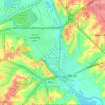
Name: Fenton topographic map, elevation, terrain.
Location: Fenton, Saint Louis County, Missouri, 63029, United States (38.50085 -90.47677 38.55822 -90.40498)
Average elevation: 489 ft
Minimum elevation: 374 ft
Maximum elevation: 676 ft
Saint Louis County trails, hiking, mountain biking, running and outdoor activities
Other topographic maps
Click on a map to view its topography, its elevation and its terrain.
University City
United States > Missouri > Saint Louis County > University City > University City
Average elevation: 558 ft
Town and Country
United States > Missouri > Saint Louis County > Town and Country > Town and Country
Average elevation: 584 ft
Jennings
United States > Missouri > Saint Louis County > Jennings > Jennings
Average elevation: 518 ft