
Allemond topographic map
Interactive map
Click on the map to display elevation.
Allemond
The EDF Centre at Baton: Electricity plant dating from the beginning of the 20th century at an altitude of 1,300 metres
About this map
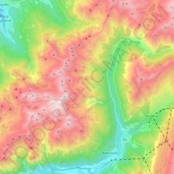
Name: Allemond topographic map, elevation, terrain.
Average elevation: 6,001 ft
Minimum elevation: 2,310 ft
Maximum elevation: 10,354 ft
Other topographic maps
Click on a map to view its topography, its elevation and its terrain.
Le Désert en Valjouffrey
France > Auvergne-Rhône-Alpes > Isère > Valjouffrey
Average elevation: 5,955 ft
Les Beauches
France > Auvergne-Rhône-Alpes > Isère > Le Sappey-en-Chartreuse
Average elevation: 3,517 ft
Les Gaudes
France > Auvergne-Rhône-Alpes > Isère > Saint-Pierre-de-Chartreuse
Average elevation: 3,484 ft
Le Col de l'Arzelier
France > Auvergne-Rhône-Alpes > Isère > Château-Bernard
Average elevation: 3,957 ft
MontGaren
France > Auvergne-Rhône-Alpes > Isère > La Chapelle-du-Bard > MontGaren
Average elevation: 2,136 ft