
Make a donation
Gear up for your next adventure:
As an Amazon Associate, this site earns from qualifying purchases at no extra cost to you.
Temescal Valley topographic map
Click on the map to display elevation.
Make a donation
Gear up for your next adventure:
As an Amazon Associate, this site earns from qualifying purchases at no extra cost to you.
About this map
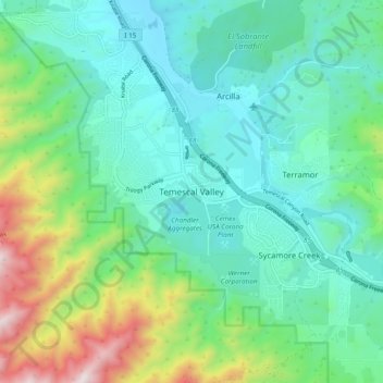
Name: Temescal Valley topographic map, elevation, terrain.
Average elevation: 1,677 ft
Minimum elevation: 860 ft
Maximum elevation: 4,180 ft
Riverside County trails, hiking, mountain biking, running and outdoor activities
Make a donation
Gear up for your next adventure:
As an Amazon Associate, this site earns from qualifying purchases at no extra cost to you.
Other topographic maps
Click on a map to view its topography, its elevation and its terrain.
La Quinta
United States > California > Riverside County
La Quinta is located at 33°40′31″N 116°17′51″W / 33.67528°N 116.29750°W / 33.67528; -116.29750 (33.675373, −116.297391). According to the United States Census Bureau, the city has a total area of 35.6 square miles (92 km2), of which 35.1 square miles (91 km2) is land and 0.4 square miles…
Average elevation: 659 ft
Palm Springs
United States > California > Riverside County
One possible origin of palm in the place name comes from early Spanish explorers who referred to the area as La Palma de la Mano de Dios or "The Palm of God's hand". The earliest use of the name "Palm Springs" is from United States Topographical Engineers who used the term in 1853 maps. According to William…
Average elevation: 2,818 ft
Make a donation
Gear up for your next adventure:
As an Amazon Associate, this site earns from qualifying purchases at no extra cost to you.
Coachella
United States > California > Riverside County
The elevation is 68 feet (21 m) below sea level, as the eastern half of the Coachella Valley is below sea level. The saltwater lake, Salton Sea, 10 miles (16 km) south of Coachella, is 228 feet (69 m) below sea level.
Average elevation: 7 ft
Lake Elsinore
United States > California > Riverside County
The rainfall until 1893 was greater than normal, and the lake remained high and overflowed naturally on three or four occasions during that time. The lake water was purchased by the Temescal Water Company for the irrigation of land in Corona. Its outlet channel was deepened, permitting gravity flow down the…
Average elevation: 1,742 ft
Palm Springs
United States > California > Riverside County
One possible origin of palm in the place name comes from early Spanish explorers who referred to the area as La Palma de la Mano de Dios or "The Palm of God's hand". The earliest use of the name "Palm Springs" is from United States Topographical Engineers who used the term in 1853 maps. According to William…
Average elevation: 2,818 ft
Make a donation
Gear up for your next adventure:
As an Amazon Associate, this site earns from qualifying purchases at no extra cost to you.
Banning
United States > California > Riverside County
Banning's elevation is approximately 2,300 feet (700 m) above sea level, which gives it a cooler climate in contrast to the county seat of Riverside at 800 feet (240 m) above sea level and the Coachella Valley of the Colorado Desert to the east.
Average elevation: 3,399 ft
Menifee
United States > California > Riverside County
The city is centrally located in Southern California in the Menifee Valley. It is almost 15 miles (24 km) north of Temecula and just north of Murrieta. Menifee is roughly 46 square miles (100 km2) in size and has an elevation of 1,424 feet (434 m). The incorporated City of Menifee includes the communities of…
Average elevation: 1,545 ft
Make a donation
Gear up for your next adventure:
As an Amazon Associate, this site earns from qualifying purchases at no extra cost to you.
Anza
United States > California > Riverside County > Anza
Anza is a census-designated place located in southwestern Riverside County, California, in the Anza Valley, a semi-arid region at a mean elevation of 3,921 feet (1,195 m) above sea level. It is located 13 miles (21 km) south of Idyllwild, 32 miles (51 km) east-northeast of Temecula, 40 miles (64 km) southwest…
Average elevation: 4,295 ft
Desert Hot Springs
United States > California > Riverside County
Summer winds and the higher elevation keep Desert Hot Springs on average 5-7 degrees cooler than other communities in Coachella Valley. However, the winter season can be warmer due to the surrounding mountains blocking north winds. Since it lies at a higher elevation than the cities further south, cold air…
Average elevation: 1,270 ft
Little Lake
United States > California > Riverside County > Lake Crest Estates
Average elevation: 1,814 ft
Make a donation
Gear up for your next adventure:
As an Amazon Associate, this site earns from qualifying purchases at no extra cost to you.
Vail Lake
United States > California > Riverside County > Butterfield Lake Estates
Average elevation: 1,519 ft
Idyllwild-Pine Cove
United States > California > Riverside County > Idyllwild
"Mile-high Idyllwild" is a mountain resort about one-mile (1,600 m) in altitude. Idyllwild is flanked by two large rock formations, Tahquitz Peak and Suicide Rock, which are famous in Southern California rock-climbing circles. It offers no skiing, so "the Hill" has been minimally developed over the years and…
Average elevation: 5,617 ft
Make a donation
Gear up for your next adventure:
As an Amazon Associate, this site earns from qualifying purchases at no extra cost to you.
Mountain Center
United States > California > Riverside County > Idyllwild
It lies centered on the junction of State Route 74 and State Route 243 in the southern division of San Bernardino National Forest. Mountain Center lies just north of Lake Hemet, midway between Hemet and Palm Desert, just south of the town of Idyllwild, and it is southeast of the city of Riverside, the county…
Average elevation: 4,839 ft
Palm Desert
United States > California > Riverside County
The elevation (at City Hall) is 224 feet (68 m) above sea level. Elevations vary from the lower northern half once covered in sand dunes to the upper slope southern cove (300–900 feet or 91–274 metres) all the way to the ridgeline at 1,000 feet (300 m). Palm Desert is in the Coachella Valley, the…
Average elevation: 584 ft
Thermal
United States > California > Riverside County > Thermal
Thermal is an unincorporated community within the Coachella Valley in Riverside County, California, United States, located approximately 25 miles (40 km) southeast of Palm Springs and about 9.5 miles (15.3 km) north of the Salton Sea. The community's elevation is 138 feet (42 m) below mean sea level. It is…
Average elevation: -115 ft
Make a donation
Gear up for your next adventure:
As an Amazon Associate, this site earns from qualifying purchases at no extra cost to you.
Calimesa
United States > California > Riverside County
Situated within the foothills of the San Bernardino Mountains, the city's elevation ranges between 2,300 to 3,500 feet (700 to 1,070 m) above sea level.
Average elevation: 2,362 ft
Make a donation
Gear up for your next adventure:
As an Amazon Associate, this site earns from qualifying purchases at no extra cost to you.
Beaumont
United States > California > Riverside County
With an elevation of 2,500-3,000 feet above sea level, Beaumont is at the peak on the San Gorgonio Pass between San Bernardino and Palm Springs, neighboring the Interstate 10 and State Route 60 freeways. If driving east to Banning or west to Calimesa, drivers can feel a gradual downward slope.
Average elevation: 2,395 ft
Riverside
United States > California > Riverside County
Riverside is the 61st-largest city in the United States, the 12th-largest city in California, and the largest city in California's Inland Empire metro area. According to the United States Census Bureau, the city has an area of 81.4 square miles (210.8 km2), of which 81.1 square miles (210 km2) is land and 0.3…
Average elevation: 1,217 ft
Make a donation
Gear up for your next adventure:
As an Amazon Associate, this site earns from qualifying purchases at no extra cost to you.
Indio
United States > California > Riverside County
Indio is home of Riverside County's eastern administration offices. Palm Springs had more people from 1955 to 1992, when the US census announced that Indio surpassed Palm Springs and that title was returned to them. The official elevation of Indio is below sea level; the city hall is 14 feet (4 m) below sea…
Average elevation: 243 ft
Make a donation
Gear up for your next adventure:
As an Amazon Associate, this site earns from qualifying purchases at no extra cost to you.
Desert Center
United States > California > Riverside County
Desert Center is a census designated place in the Colorado Desert in Riverside County, California. It is in southern California, between the cities of Indio and Blythe at the junction of Interstate 10 and State Route 177, about halfway between Phoenix and Los Angeles. The ZIP Code is 92239, and the community…
Average elevation: 761 ft
Colorado River
United States > California > Riverside County > Blythe
The entire eastern boundary of the Colorado River Basin runs along the North American Continental Divide and is defined largely by the Rocky Mountains. The Wind River Range in Wyoming marks the northern extent of the basin, and is separated from the Colorado Rockies by the endorheic Great Divide Basin in…
Average elevation: 335 ft
Make a donation
Gear up for your next adventure:
As an Amazon Associate, this site earns from qualifying purchases at no extra cost to you.
Santa Margarita Ecological Reserve
United States > California > Riverside County > Temecula
Average elevation: 1,296 ft
Thousand Palms
United States > California > Riverside County > Thousand Palms
Average elevation: 354 ft
Sycamore Canyon Wilderness Park
United States > California > Riverside County > Riverside
Average elevation: 1,434 ft
Make a donation
Gear up for your next adventure:
As an Amazon Associate, this site earns from qualifying purchases at no extra cost to you.
Mesa Verde
United States > California > Riverside County
Mesa Verde (Spanish for 'Green Table') is a census-designated place in Riverside County, California. Mesa Verde sits at an elevation of 390 feet (120 m). The 2020 United States census reported Mesa Verde's population was 766.
Average elevation: 394 ft
Gale Webb Action Sports Park
United States > California > Riverside County > Menifee
Average elevation: 1,512 ft
Colorado River
United States > California > Riverside County > Blythe
The entire eastern boundary of the Colorado River Basin runs along the North American Continental Divide and is defined largely by the Rocky Mountains and the Rio Grande Basin. The Wind River Range in Wyoming marks the northern extent of the basin, and is separated from the Colorado Rockies by the endorheic…
Average elevation: 335 ft
Make a donation
Gear up for your next adventure:
As an Amazon Associate, this site earns from qualifying purchases at no extra cost to you.
Hemet
United States > California > Riverside County
Dedicated to James Simpson, Hemet City Council 1947–48, and mayor 1950 to 1966. Simpson Park is a wilderness park located in the Santa Rosa Hills southeast of Hemet with sheltered picnic area and tables, barbecues, restrooms, and hiking trails. At an elevation of 2,500 feet (760 m), it provides an expansive…
Average elevation: 1,755 ft
Riverside
United States > California > Riverside County
Riverside is the 59th largest city in the United States, the 12th largest city in California, and the largest city in California's Inland Empire metro area. According to the United States Census Bureau, the city has a total area of 81.4 square miles (210.8 km2), of which 81.1 square miles (210 km2) is land and…
Average elevation: 1,217 ft
Palm Springs
United States > California > Riverside County
One possible origin of palm in the place name comes from early Spanish explorers who referred to the area as La Palma de la Mano de Dios or "The Palm of God's hand". The earliest use of the name "Palm Springs" is from United States Topographical Engineers who used the term in 1853 maps. According to William…
Average elevation: 2,815 ft
Beaumont
United States > California > Riverside County
With an elevation of 2,500 to 3,000 feet (760 to 910 m) above sea level, Beaumont is at the peak on the San Gorgonio Pass between San Bernardino and Palm Springs, neighboring the Interstate 10 and State Route 60 freeways. If driving east to Banning or west to Calimesa, drivers can feel a gradual downward slope.
Average elevation: 2,395 ft
Make a donation
Gear up for your next adventure:
As an Amazon Associate, this site earns from qualifying purchases at no extra cost to you.
La Quinta
United States > California > Riverside County
La Quinta is located at 33°40′31″N 116°17′51″W / 33.67528°N 116.29750°W / 33.67528; -116.29750 (33.675373, −116.297391). According to the United States Census Bureau, the city has a total area of 35.6 square miles (92 km2), of which 35.1 square miles (91 km2) is land and 0.4 square miles…
Average elevation: 659 ft
Palm Desert
United States > California > Riverside County
The elevation (City hall) is 224 feet (68 m) above sea level. Elevations vary from the lower northern half once covered in sand dunes to the upper slope southern cove (300–900 feet or 91–274 metres) all the way to the ridgeline at 1,000 feet (300 m). Palm Desert is located in the Coachella Valley, the…
Average elevation: 584 ft
San Jacinto / Lake Perris Core Reserve
United States > California > Riverside County > Moreno Valley
Average elevation: 1,565 ft
Make a donation
Gear up for your next adventure:
As an Amazon Associate, this site earns from qualifying purchases at no extra cost to you.
Mountain Center
United States > California > Riverside County
It lies centered on the junction of State Route 74 and State Route 243 in the southern division of San Bernardino National Forest. Mountain Center lies just north of Lake Hemet, midway between Hemet and Palm Desert, just south of the town of Idyllwild, and it is southeast of the city of Riverside, the county…
Average elevation: 4,843 ft
Cherry Valley
United States > California > Riverside County > Beaumont
With an elevation of 2,980 feet above sea level, Cherry Valley is at the highest point on the San Gorgonio Pass between San Bernardino and Palm Springs. According to the United States Census Bureau, the CDP has a total area of 8.1 square miles (21 km2), all of it land.
Average elevation: 3,091 ft
Make a donation
Gear up for your next adventure:
As an Amazon Associate, this site earns from qualifying purchases at no extra cost to you.
Hemet
United States > California > Riverside County
Dedicated to James Simpson, Hemet City Council from 1947 to 48, and mayor from 1950 to 1966, Simpson Park is a wilderness park located in the Santa Rosa Hills southeast of Hemet with sheltered picnic area and tables, barbecues, restrooms, and hiking trails. At an elevation of 2,500 feet (760 m), it provides an…
Average elevation: 1,755 ft
Aguanga
United States > California > Riverside County
Aguanga (/əˈwɑːŋ.ɡə/; Luiseño: Awáanga, meaning "dog place") is a census-designated place located within the Inland Empire in Riverside County, California. It is located about 18 miles (29 km) east of Temecula and 22 miles (35 km) south-southeast of Hemet. Aguanga lies at an elevation of 1955 feet…
Average elevation: 2,379 ft
Make a donation
Gear up for your next adventure:
As an Amazon Associate, this site earns from qualifying purchases at no extra cost to you.
Indio
United States > California > Riverside County
According to the United States Census Bureau, the city has a total area of 86.1 square kilometers (33 sq mi), 99.98% of which is land and 0.02% is water. The official elevation of Indio is below sea level; the city hall is 14 feet (4 m) below sea level, as the eastern half of the Coachella Valley drops as low…
Average elevation: 243 ft
Anza
United States > California > Riverside County > Anza
Anza is a census-designated place in Riverside County, California, in the Anza Valley, a semi-arid region at a mean elevation of 3,921 feet (1,195 m) above sea level. It is located 13 miles (21 km) south of Idyllwild, 32 miles (51 km) east-northeast of Temecula, 40 miles (64 km) southwest of Palm Springs, and…
Average elevation: 4,295 ft
Make a donation
Gear up for your next adventure:
As an Amazon Associate, this site earns from qualifying purchases at no extra cost to you.
Make a donation
Gear up for your next adventure:
As an Amazon Associate, this site earns from qualifying purchases at no extra cost to you.
Lake Elsinore
United States > California > Riverside County
The rainfall until 1893 was greater than normal, and the lake remained high and overflowed naturally on three or four occasions during that time. The lake water was purchased by the Temescal Water Company for the irrigation of land in Corona. Its outlet channel was deepened, permitting gravity flow down the…
Average elevation: 1,742 ft
Palm Desert
United States > California > Riverside County
The elevation (City hall) is 224 feet (68 m) above sea level. Elevations vary from the lower northern half once covered in sand dunes to the upper slope southern cove (300–900 feet or 91–274 metres) all the way to the ridgeline at 1,000 feet (300 m). Palm Desert is located in the Coachella Valley, the…
Average elevation: 584 ft
Make a donation
Gear up for your next adventure:
As an Amazon Associate, this site earns from qualifying purchases at no extra cost to you.
Make a donation
Gear up for your next adventure:
As an Amazon Associate, this site earns from qualifying purchases at no extra cost to you.
Cherry Valley
United States > California > Riverside County
With an elevation of 2,980 feet above sea level, Cherry Valley is at the highest point on the San Gorgonio Pass between San Bernardino and Palm Springs. According to the United States Census Bureau, the CDP has a total area of 8.1 square miles (21 km2), all of it land.
Average elevation: 3,061 ft
Mountain Center
United States > California > Riverside County > Idyllwild
It lies centered on the junction of State Route 74 and State Route 243 in the southern division of San Bernardino National Forest. Mountain Center lies just north of Lake Hemet, midway between Hemet and Palm Desert, just south of the town of Idyllwild, and it is southeast of the city of Riverside, the county…
Average elevation: 4,839 ft
Make a donation
Gear up for your next adventure:
As an Amazon Associate, this site earns from qualifying purchases at no extra cost to you.
La Quinta
United States > California > Riverside County
According to the United States Census Bureau, the city has a total area of 35.6 square miles (92 km2), of which 35.1 square miles (91 km2) is land and 0.4 square miles (1.0 km2) (1.22%) is water. The city's elevation is 56 feet (20 m) above sea level.
Average elevation: 659 ft
Riverside
United States > California > Riverside County
Riverside is the 59th-most populous city in the United States, the 12th-most populous city in California, and the largest city in California's Inland Empire metro area. According to the United States Census Bureau, the city has an area of 81.4 square miles (210.8 km2), of which 81.1 square miles (210 km2) is…
Average elevation: 1,217 ft
Menifee
United States > California > Riverside County
The city is centrally located in Southern California in the Menifee Valley. It is almost 15 miles (24 km) north of Temecula and just north of Murrieta. Menifee is roughly 46 square miles (100 km2) in size and has an elevation of 1,424 feet (434 m). The incorporated City of Menifee includes the communities of…
Average elevation: 1,545 ft
Make a donation
Gear up for your next adventure:
As an Amazon Associate, this site earns from qualifying purchases at no extra cost to you.
Riverside
United States > California > Riverside County
Riverside is the 59th-most populous city in the United States, the 12th-most populous city in California, and the largest city in California's Inland Empire metro area. According to the United States Census Bureau, the city has an area of 81.4 square miles (210.8 km2), of which 81.1 square miles (210 km2) is…
Average elevation: 1,217 ft
Make a donation
Gear up for your next adventure:
As an Amazon Associate, this site earns from qualifying purchases at no extra cost to you.
Calimesa
United States > California > Riverside County
Situated within the foothills of the San Bernardino Mountains, the city's elevation ranges between 2,300 to 3,500 feet (700 to 1,070 m) above sea level.
Average elevation: 2,362 ft
Palm Desert
United States > California > Riverside County > Palm Desert
The elevation (at City Hall) is 224 feet (68 m) above sea level. Elevations vary from the lower northern half once covered in sand dunes to the upper slope southern cove (300–900 feet or 91–274 metres) all the way to the ridgeline at 1,000 feet (300 m). Palm Desert is in the Coachella Valley, the…
Average elevation: 994 ft
Palm Springs
United States > California > Riverside County
One possible origin of palm in the place name comes from early Spanish explorers who referred to the area as La Palma de la Mano de Dios or "The Palm of God's hand". The earliest use of the name "Palm Springs" is from United States Topographical Engineers who used the term in 1853 maps. According to William…
Average elevation: 2,818 ft
Make a donation
Gear up for your next adventure:
As an Amazon Associate, this site earns from qualifying purchases at no extra cost to you.
Coachella
United States > California > Riverside County
The elevation is 68 feet (21 m) below sea level, as the eastern half of the Coachella Valley is below sea level. The saltwater lake, Salton Sea, 10 miles (16 km) south of Coachella, is 228 feet (69 m) below sea level.
Average elevation: 7 ft
Beaumont
United States > California > Riverside County
With an elevation of 2,500 to 3,000 feet (760 to 910 m) above sea level, Beaumont is at the peak on the San Gorgonio Pass between San Bernardino and Palm Springs, neighboring the Interstate 10 and State Route 60 freeways. If driving east to Banning or west to Calimesa, drivers can feel a gradual downward slope.
Average elevation: 2,395 ft
Make a donation
Gear up for your next adventure:
As an Amazon Associate, this site earns from qualifying purchases at no extra cost to you.