
Tuzla Canton topographic map
Interactive map
Click on the map to display elevation.
About this map
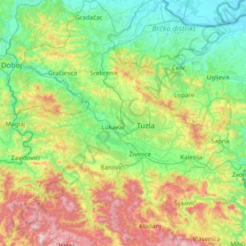
Name: Tuzla Canton topographic map, elevation, terrain.
Average elevation: 1,352 ft
Minimum elevation: 259 ft
Maximum elevation: 4,718 ft
Other topographic maps
Click on a map to view its topography, its elevation and its terrain.
Sarajevo
Bosnia and Herzegovina > Federation of Bosnia and Herzegovina > Sarajevo
Average elevation: 3,117 ft
Tuzla
Bosnia and Herzegovina > Federation of Bosnia and Herzegovina > City of Tuzla
Average elevation: 1,145 ft
Čapljina
Bosnia and Herzegovina > Federation of Bosnia and Herzegovina > City of Čapljina
Average elevation: 322 ft
Zenica
Bosnia and Herzegovina > Federation of Bosnia and Herzegovina > City of Zenica
The city is geographically located in the heart of Bosnia. The settled area is 43.01 km2 (16.61 sq mi) and of the city proper covers 558.5 km2 (215.6 sq mi). Elevation is 310–350 m (1,017–1,148 ft). The rivers Bosna, Lašva, Babina, and Kočeva flow through the settlement. A moderate continental climate…
Average elevation: 2,395 ft
Žitomislići
Bosnia and Herzegovina > Federation of Bosnia and Herzegovina > City of Mostar
Average elevation: 630 ft
Rama
Bosnia and Herzegovina > Federation of Bosnia and Herzegovina > Gračanica
Average elevation: 2,385 ft
Velež
Bosnia and Herzegovina > Federation of Bosnia and Herzegovina > Town of Zavidovići
Average elevation: 1,759 ft
Tešanj
Bosnia and Herzegovina > Federation of Bosnia and Herzegovina
Tešanj is located at an altitude of 230 meters and developed around the river Tešanjka. The town is surrounded by many hills.
Average elevation: 961 ft
Boračko jezero
Bosnia and Herzegovina > Federation of Bosnia and Herzegovina > Town of Konjic > Jezero
It lies at the northeastern foot of the mountain Prenj, at an altitude 397 m. From the west it is surrounded by steep forested mountain slopes of Crna Gora (Black Mountain, 1343 m), and from the east by Tranjine (1055 m). The lake basin was created in the Boračka draga, during the expansive process of glacial…
Average elevation: 2,185 ft
Bugojno
Bosnia and Herzegovina > Federation of Bosnia and Herzegovina
The municipality has an average elevation of 570 metres above sea level. Much of its 366 km2 is forested. The terrain is mountainous with several prominent features. Stožer (1662m), Kalin (1,530m) and Rudina (1,385m) are the tallest mountains in Bugojno.
Average elevation: 2,123 ft
Lukavac
Bosnia and Herzegovina > Federation of Bosnia and Herzegovina > Town of Lukavac
Average elevation: 728 ft
Široki Brijeg
Bosnia and Herzegovina > Federation of Bosnia and Herzegovina > City of Široki Brijeg
Neogenic layers are built of marl, sandy clay, sandstone and conglomerates, and can be found in the vicinity of Grabovo Drage and Mostarsko Blato. Quaternary banks of pebbles, sand and water karst saturated found on almost all rocky fields and drifts along the river beds. Between the lower mountain Vardi,…
Average elevation: 1,329 ft
Mostar
Bosnia and Herzegovina > Federation of Bosnia and Herzegovina > City of Mostar
Average elevation: 1,975 ft
Dinaric Alps
Bosnia and Herzegovina > Federation of Bosnia and Herzegovina > City of Livno
Average elevation: 5,246 ft
Jablanica
Bosnia and Herzegovina > Federation of Bosnia and Herzegovina
The mean elevation of Jablanica is 202 metres (663 ft) above sea level. Some 69% of the municipalities 301 km2 (116 sq mi) of area is forested. The Jablanica lake is an important geographical as well as economic presence in Jablanica.
Average elevation: 1,535 ft
Lom
Bosnia and Herzegovina > Federation of Bosnia and Herzegovina > Stari Teočak
Average elevation: 1,644 ft
Novi Travnik
Bosnia and Herzegovina > Federation of Bosnia and Herzegovina > Novi Travnik
Average elevation: 2,264 ft
Srebrenik
Bosnia and Herzegovina > Federation of Bosnia and Herzegovina > Town of Srebrenik > Srebrenik
Average elevation: 948 ft
Livno
Bosnia and Herzegovina > Federation of Bosnia and Herzegovina > City of Livno
Average elevation: 2,976 ft
Vučipolje
Bosnia and Herzegovina > Federation of Bosnia and Herzegovina > Vučipolje
Average elevation: 3,350 ft
Tomislavgrad
Bosnia and Herzegovina > Federation of Bosnia and Herzegovina
Average elevation: 2,995 ft
Stolac
Bosnia and Herzegovina > Federation of Bosnia and Herzegovina > Town of Stolac
Average elevation: 951 ft
Cazin
Bosnia and Herzegovina > Federation of Bosnia and Herzegovina > Cazin
Average elevation: 1,227 ft
Visoko
Bosnia and Herzegovina > Federation of Bosnia and Herzegovina > Grad Visoko
The Visoko municipality covers 232 square kilometres with several characteristic, morphologically distinctive valleys formed by the foothills of the Central Bosnian mountains including Ozren, Vranica and Zvijezda. The altitude of the region ranges from 400 to 1,050 metres. Visoko's natural environment is…
Average elevation: 1,729 ft
Čapljina
Bosnia and Herzegovina > Federation of Bosnia and Herzegovina > Čapljina
Average elevation: 322 ft
Dubrovnik
Bosnia and Herzegovina > Federation of Bosnia and Herzegovina > Kamenica
Average elevation: 2,772 ft
Pribava
Bosnia and Herzegovina > Federation of Bosnia and Herzegovina > Town of Gračanica > Pribava
Average elevation: 682 ft
Gračanica
Bosnia and Herzegovina > Federation of Bosnia and Herzegovina > Town of Gračanica > Gračanica
Average elevation: 876 ft