
Veszprém topographic map
Interactive map
Click on the map to display elevation.
About this map
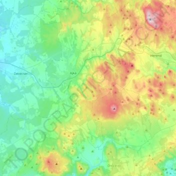
Name: Veszprém topographic map, elevation, terrain.
Location: Ajkai járás, Veszprém, Transdanubia, Hungary (46.94083 17.35517 47.22091 17.74673)
Average elevation: 974 ft
Minimum elevation: 502 ft
Maximum elevation: 2,116 ft
Other topographic maps
Click on a map to view its topography, its elevation and its terrain.
Kékes
Kékes Peak is the highest altitude region in Hungary, so it has the highest altitude weather station in the country. Although the mountain is still classified as a temperate humid continental climate (Dfb) according to the Köppen climate classification, it is very close to a subarctic climate (Dfc). Unlike…
Average elevation: 2,680 ft
Pécs
Pécs is bordered by plains to the south (elevation 120–130 m), while the Mecsek mountains rise up to elevations of 400–600 meters behind the city. Jakab-hill, located in the western Mecsek, is 592 m (1942 ft) tall, Tubes, straight above Pécs, is 612 m (2008 ft) tall, and Misina is 535 m (1755 ft) tall.…
Average elevation: 689 ft