
City of Hobsons Bay topographic map
Interactive map
Click on the map to display elevation.
About this map
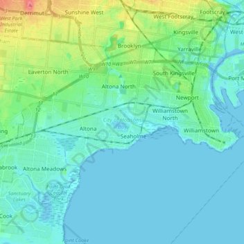
Name: City of Hobsons Bay topographic map, elevation, terrain.
Location: City of Hobsons Bay, Victoria, Australia (-37.90006 144.75143 -37.81383 144.91552)
Average elevation: 39 ft
Minimum elevation: -13 ft
Maximum elevation: 203 ft
Other topographic maps
Click on a map to view its topography, its elevation and its terrain.
Melbourne
Australia > Victoria > Melbourne
Melbourne is also prone to isolated convective showers forming when a cold pool crosses the state, especially if there is considerable daytime heating. These showers are often heavy and can include hail, squalls, and significant drops in temperature, but they often pass through very quickly with a rapid…
Average elevation: 161 ft
Ballarat
Ballarat has a moderate oceanic climate (Köppen climate classification Cfb) with four distinct seasons. Its elevation, ranging between 400 and 630 metres (1,310 and 2,070 feet) above sea level, causes its mean monthly temperatures to tend to be on average 3 to 5 °C (5 to 9 °F) below those of Melbourne,…
Average elevation: 1,542 ft
Narre Warren North Retarding Basin (Melbourne Water)
Australia > Victoria > Melbourne
Average elevation: 249 ft
Frankston
Australia > Victoria > Frankston
Olivers Hill is the most prominent elevation in Frankston which rises to 55 metres above sea level (180 feet) at its highest point in the suburb. Its origins date to approximately 415 to 360 million years ago. Its base is Mount Eliza Granite dating from the Devonian period, which was covered in lava tuffs in…
Average elevation: 118 ft