
Make a donation
Gear up for your next adventure:
As an Amazon Associate, this site earns from qualifying purchases at no extra cost to you.
Portland topographic map
Click on the map to display elevation.
Make a donation
Gear up for your next adventure:
As an Amazon Associate, this site earns from qualifying purchases at no extra cost to you.
Portland
Portland features a striking and varied topography characterized by its location at the confluence of the Willamette and Columbia Rivers. The city lies within the fertile Willamette Valley, flanked by the snow-capped Cascade Mountains to the east, including the prominent Mount Hood, and the less elevated Coastal Range to the west. This setting creates a dramatic backdrop of rugged terrain and lush forests, with elevations ranging from about 161 feet at the riverside to 1,188 feet in the surrounding hills. The interplay between the rivers and the mountains not only shapes the urban landscape but also influences local climate patterns, fostering a rich biodiversity and extensive green spaces throughout the city. Additionally, the nearby Columbia River Gorge adds to the area's natural beauty, featuring steep cliffs and numerous waterfalls, making Portland's topography one of the most diverse and visually appealing in the Pacific Northwest.
Make a donation
Gear up for your next adventure:
As an Amazon Associate, this site earns from qualifying purchases at no extra cost to you.
About this map
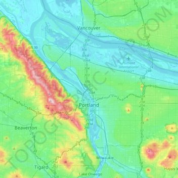
Name: Portland topographic map, elevation, terrain.
Location: Portland, Multnomah County, Oregon, United States (45.43254 -122.83675 45.65288 -122.47203)
Average elevation: 253 ft
Minimum elevation: -16 ft
Maximum elevation: 1,253 ft
Multnomah County trails, hiking, mountain biking, running and outdoor activities
Make a donation
Gear up for your next adventure:
As an Amazon Associate, this site earns from qualifying purchases at no extra cost to you.
Other topographic maps
Click on a map to view its topography, its elevation and its terrain.
Make a donation
Gear up for your next adventure:
As an Amazon Associate, this site earns from qualifying purchases at no extra cost to you.
Governor Tom McCall Waterfront Park
United States > Oregon > Multnomah County > Portland
Average elevation: 85 ft
Rocky Butte
United States > Oregon > Multnomah County > Portland
Rocky Butte lies in the northeast part of Portland within the city limits, in Multnomah County, part of the U. S. state of Oregon. It is one of the few smaller volcanic cones within or near Portland, along with Mount Tabor, Kelly Butte, and Powell Butte. According to the U.S. National Geodetic Survey, Rocky…
Average elevation: 220 ft
Make a donation
Gear up for your next adventure:
As an Amazon Associate, this site earns from qualifying purchases at no extra cost to you.
Make a donation
Gear up for your next adventure:
As an Amazon Associate, this site earns from qualifying purchases at no extra cost to you.
Make a donation
Gear up for your next adventure:
As an Amazon Associate, this site earns from qualifying purchases at no extra cost to you.