
Eagle Cap Wilderness topographic map
Interactive map
Click on the map to display elevation.
About this map
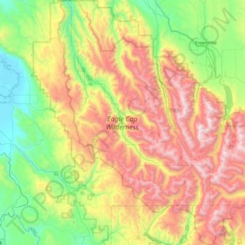
Name: Eagle Cap Wilderness topographic map, elevation, terrain.
Average elevation: 5,344 ft
Minimum elevation: 2,677 ft
Maximum elevation: 9,760 ft
Other topographic maps
Click on a map to view its topography, its elevation and its terrain.
Big Canyon Fish Weir
United States > Oregon > Wallowa County
Big Canyon Fish Weir, Wallowa County, Oregon, United States
Average elevation: 3,097 ft
Enterprise
United States > Oregon > Wallowa County
Enterprise, Wallowa County, Oregon, United States
Average elevation: 3,812 ft
Troy
United States > Oregon > Wallowa County
Troy, Wallowa County, Oregon, United States
Average elevation: 2,333 ft
Imnaha
United States > Oregon > Wallowa County > Imnaha
Imnaha, Wallowa County, Oregon, 97842, United States
Average elevation: 2,825 ft
Wallowa
United States > Oregon > Wallowa County > Wallowa
Wallowa, Wallowa County, Oregon, 97885, United States
Average elevation: 3,074 ft
Joseph
United States > Oregon > Wallowa County
Joseph, Wallowa County, Oregon, 97846, United States
Average elevation: 4,216 ft