
Missaukee County topographic map
Interactive map
Click on the map to display elevation.
About this map
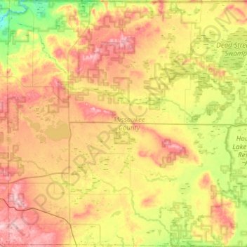
Name: Missaukee County topographic map, elevation, terrain.
Location: Missaukee County, Michigan, United States (44.16134 -85.33826 44.51232 -84.85086)
Average elevation: 1,214 ft
Minimum elevation: 942 ft
Maximum elevation: 1,535 ft
Michigan trails, hiking, mountain biking, running and outdoor activities
Other topographic maps
Click on a map to view its topography, its elevation and its terrain.
Horseshoe Lake
United States > Michigan > Marquette County > Republic Township
Average elevation: 1,650 ft
Rawsonville
United States > Michigan > Washtenaw County > Ypsilanti Charter Township
Average elevation: 702 ft
South Fox Island
United States > Michigan > Leelanau County
North Fox Island has an operational public 3,001-foot-long by 100-foot-wide (914m x 30m) grass airstrip as of August 2023, making it accessible by general aviation. Runway 7 has a displaced threshold of 804 ft. and Runway 25 has a displaced threshold of 999 ft. Both runways have trees at their ends ranging…
Average elevation: 607 ft
Grand Mere State Park
United States > Michigan > Berrien County > Stevensville
Average elevation: 607 ft
Village of Dansville Community Park
United States > Michigan > Ingham County > Dansville
Average elevation: 948 ft
Mooreville
United States > Michigan > Washtenaw County > York Charter Township
Average elevation: 728 ft
Dollar Lake
United States > Michigan > Oakland County > Independence Charter Township
Average elevation: 1,004 ft
Charlevoix South Pier Light
United States > Michigan > Charlevoix County > Charlevoix
Average elevation: 591 ft
Hatchs
United States > Michigan > Leelanau County > Elmwood Charter Township
Average elevation: 728 ft
Grand Mere State Park
United States > Michigan > Berrien County > Stevensville
Average elevation: 607 ft
Carpenter Lake Nature Preserve
United States > Michigan > Oakland County > Southfield
Average elevation: 679 ft
Oxbow
United States > Michigan > Oakland County > White Lake Charter Township
Average elevation: 961 ft
New Hudson
United States > Michigan > Oakland County > Lyon Charter Township
Average elevation: 951 ft