
Willcox topographic map
Interactive map
Click on the map to display elevation.
Willcox
Willcox's high elevation gives it a milder climate than the nearby Valley of the Sun and Sonoran Desert. It also receives more rainfall than Tucson and Phoenix due to the summer monsoon rains and thus it has a hot semi-arid climate (Koppen: BSh)
About this map
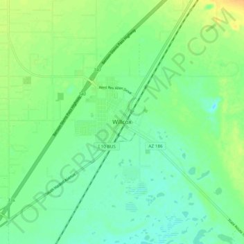
Name: Willcox topographic map, elevation, terrain.
Location: Willcox, Cochise County, Arizona, 85643, United States (32.21291 -109.87158 32.29291 -109.79158)
Average elevation: 4,180 ft
Minimum elevation: 4,144 ft
Maximum elevation: 4,232 ft
Cochise County trails, hiking, mountain biking, running and outdoor activities
Other topographic maps
Click on a map to view its topography, its elevation and its terrain.
Sierra Vista
United States > Arizona > Cochise County
In the Köppen climate classification system, Sierra Vista falls within the typical cold semi-arid climate (BSk) of mid-altitude Arizona. Fall and spring, like most other parts of Arizona, are very dry. Winters are cool to cold with frosts which can occasionally be hard freezes; frost can be expected to stop…
Average elevation: 4,964 ft
Tombstone
United States > Arizona > Cochise County
The Tombstone District located at 31°42′57″N 110°3′53″W / 31.71583°N 110.06472°W / 31.71583; -110.06472 (31.715940, −110.064827) sits atop a mesa (elevation 4,539 feet [1,383 m]) in the San Pedro River valley between the Huachuca Mountains and Whetstone Mountains to the west, and the…
Average elevation: 4,475 ft
Sierra Vista
United States > Arizona > Cochise County
In the Köppen climate classification system, Sierra Vista falls within the typical cold semi-arid climate (BSk) of mid-altitude Arizona. Fall and spring, like most other parts of Arizona, are very dry. Winters are cool to cold with frosts which can occasionally be hard freezes; frost can be expected to stop…
Average elevation: 4,944 ft