
Tombstone topographic map
Click on the map to display elevation.
Tombstone
The Tombstone District located at 31°42′57″N 110°3′53″W / 31.71583°N 110.06472°W / 31.71583; -110.06472 (31.715940, −110.064827) sits atop a mesa (elevation 4,539 feet [1,383 m]) in the San Pedro River valley between the Huachuca Mountains and Whetstone Mountains to the west, and the Mules and the Dragoon Mountains to the east. According to the United States Census Bureau, the city has a total area of 4.3 square miles (11.2 km2), all land.
About this map
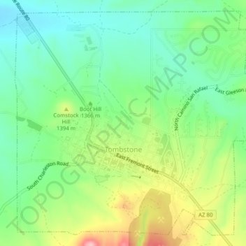
Name: Tombstone topographic map, elevation, terrain.
Location: Tombstone, Cochise County, Arizona, 85638, United States (31.70272 -110.08222 31.73268 -110.04366)
Average elevation: 4,475 ft
Minimum elevation: 4,288 ft
Maximum elevation: 4,816 ft
Cochise County trails, hiking, mountain biking, running and outdoor activities
Other topographic maps
Click on a map to view its topography, its elevation and its terrain.
Willcox
United States > Arizona > Cochise County
Willcox's high elevation gives it a milder climate than the nearby Valley of the Sun and Sonoran Desert. It also receives more rainfall than Tucson and Phoenix due to the summer monsoon rains and thus it has a hot semi-arid climate (Koppen: BSh)
Average elevation: 4,180 ft
Sierra Vista Estates
United States > Arizona > Cochise County > Sierra Vista
Average elevation: 4,688 ft
Willcox
United States > Arizona > Cochise County
Willcox's high elevation gives it a milder climate than the nearby Valley of the Sun and Sonoran Desert. It also receives more rainfall than Tucson and Phoenix due to the summer monsoon rains and thus it has a hot semi-arid climate (Koppen: BSh).
Average elevation: 4,180 ft
Bakerville
United States > Arizona > Cochise County > Bisbee > Warren
Bakerville is a populated place situated within the city of Bisbee in Cochise County, Arizona, United States. It has an estimated elevation of 5,039 feet (1,536 m) above sea level.
Average elevation: 5,180 ft