
Sumatra topographic map
Interactive map
Click on the map to display elevation.
About this map
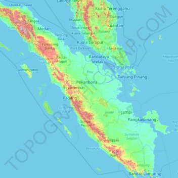
Name: Sumatra topographic map, elevation, terrain.
Location: Sumatra, Indonesia (-5.94309 95.19356 5.65659 106.09665)
Average elevation: 305 ft
Minimum elevation: -10 ft
Maximum elevation: 11,243 ft
Other topographic maps
Click on a map to view its topography, its elevation and its terrain.
Tebing Tinggi
Indonesia > North Sumatra > Kota Tebing Tinggi–Serdang Bedagai
Average elevation: 112 ft
Cepetsari Glagahharjo
Indonesia > Special Region of Yogyakarta > Sleman Regency > Glagah Harjo
Average elevation: 1,640 ft
Janti
Indonesia > Special Region of Yogyakarta > Sleman Regency > Catur tunggal
Average elevation: 407 ft
Ciliwung
Mean rainfall reaches 3,125 mm, with a mean annual discharge of 16 m3/s as measured at Ciliwung Ratujaya observation station (231 km2). With such topographical, geological, and hydrological features, the Ciliwung River is often overflowing and inundating parts of Jakarta. The population along the Ciliwung…
Average elevation: 1,076 ft