
Kutaisi topographic map
Interactive map
Click on the map to display elevation.
About this map
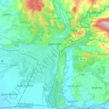
Name: Kutaisi topographic map, elevation, terrain.
Location: Kutaisi, Imereti, Georgia (42.19712 42.60616 42.32094 42.74188)
Average elevation: 620 ft
Minimum elevation: 305 ft
Maximum elevation: 1,965 ft
Kutaisi is located along both banks of the Rioni River. The city lies at an elevation of 125–300 metres (410–984 feet) above sea level. To the east and northeast, Kutaisi is bounded by the Northern Imereti Foothills, to the north by the Samgurali Range, and to the west and the south by the Colchis Plain.
Other topographic maps
Click on a map to view its topography, its elevation and its terrain.
Baghdati Municipality
Baghdati Municipality, Imereti, 1000, Georgia
Average elevation: 3,107 ft
Samtredia
Georgia > Imereti > Samtredia Municipality
Samtredia, Samtredia Municipality, Imereti, 3900, Georgia
Average elevation: 85 ft
Sairme
Georgia > Imereti > Vani Municipality > Sairme
Sairme, Vani Municipality, Imereti, Georgia
Average elevation: 4,196 ft