
Parkville topographic map
Interactive map
Click on the map to display elevation.
About this map
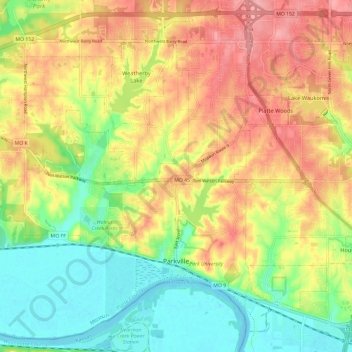
Name: Parkville topographic map, elevation, terrain.
Location: Parkville, Platte County, Missouri, 64152, United States (39.16925 -94.77052 39.25437 -94.65206)
Average elevation: 896 ft
Minimum elevation: 728 ft
Maximum elevation: 1,076 ft
Platte County trails, hiking, mountain biking, running and outdoor activities
Other topographic maps
Click on a map to view its topography, its elevation and its terrain.