Geolocate

Waldron topographic map

Click on the map to display elevation.

About this map

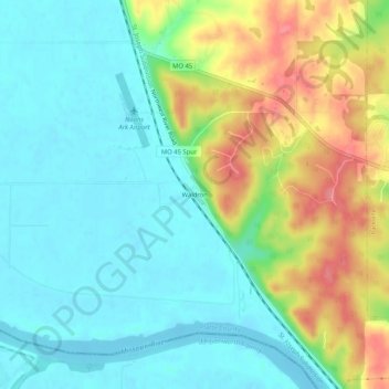
Name: Waldron topographic map, elevation, terrain.

Location: Waldron, Platte County, Missouri, 64092, United States (39.20222 -94.81329 39.24222 -94.77329)

Average elevation: 830 ft

Minimum elevation: 735 ft

Maximum elevation: 1,017 ft

Platte County trails, hiking, mountain biking, running and outdoor activities

Other topographic maps

Click on a map to view its topography, its elevation and its terrain.

Weatherby Lake

United States > Missouri > Platte County

Average elevation: 938 ft

Dearborn

United States > Missouri > Platte County

Average elevation: 942 ft

Ridgely

United States > Missouri > Platte County

A post office called Ridgely was established in 1848, and remained in operation until 1902. The community most likely was so named on account of its lofty elevation.

Average elevation: 909 ft

Tracy

United States > Missouri > Platte County

Average elevation: 823 ft

Iatan

United States > Missouri > Platte County

Average elevation: 860 ft

Camden Point

United States > Missouri > Platte County

Average elevation: 915 ft

Farley

United States > Missouri > Platte County

Average elevation: 797 ft

Gear up for your next adventure:

🥾Men's Hiking Boots - Durable, waterproof footwear for rugged terrain and steep inclines
🛰️Handheld GPS Units - Professional satellite navigators for precise backcountry mapping
🎒Trekking Poles - Sturdy poles for balance and stability on rough terrain
🚑Emergency Bivvies - Heat-reflective sleeping bags for survival situations
🪑Portable Camp Table - Compact table for campsite meals

As an Amazon Associate, this site earns from qualifying purchases at no extra cost to you.