Geolocate

Sadler topographic map

Click on the map to display elevation.

About this map

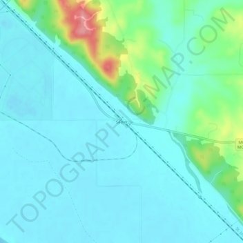
Name: Sadler topographic map, elevation, terrain.

Location: Sadler, Platte County, Missouri, 64098, United States (39.41861 -94.96191 39.45861 -94.92191)

Average elevation: 827 ft

Minimum elevation: 761 ft

Maximum elevation: 1,119 ft

Platte County trails, hiking, mountain biking, running and outdoor activities

Other topographic maps

Click on a map to view its topography, its elevation and its terrain.

Weatherby Lake

United States > Missouri > Platte County

Average elevation: 938 ft

Dearborn

United States > Missouri > Platte County

Average elevation: 942 ft

Ridgely

United States > Missouri > Platte County

A post office called Ridgely was established in 1848, and remained in operation until 1902. The community most likely was so named on account of its lofty elevation.

Average elevation: 909 ft

Tracy

United States > Missouri > Platte County

Average elevation: 823 ft

Iatan

United States > Missouri > Platte County

Average elevation: 860 ft

Camden Point

United States > Missouri > Platte County

Average elevation: 915 ft

Farley

United States > Missouri > Platte County

Average elevation: 797 ft

Gear up for your next adventure:

🧼Biodegradable Camping Soap - Eco‑friendly soap for outdoor hygiene
🪵Folding Camp Saw - Compact saw for wood and campsite work
🗻Climbing Gear Basics - Essential gear for beginner climbers
🕶️GPS Smartphone Mount - Secure mount for phone navigation
🛰️Handheld GPS Units - Professional satellite navigators for precise backcountry mapping

As an Amazon Associate, this site earns from qualifying purchases at no extra cost to you.