
Wexford topographic map
Interactive map
Click on the map to display elevation.
About this map
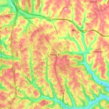
Name: Wexford topographic map, elevation, terrain.
Average elevation: 1,184 ft
Minimum elevation: 958 ft
Maximum elevation: 1,345 ft
Allegheny County trails, hiking, mountain biking, running and outdoor activities
Other topographic maps
Click on a map to view its topography, its elevation and its terrain.
Pittsburgh
United States > Pennsylvania > Allegheny County
Pittsburgh, located in Allegheny County, Pennsylvania, is characterized by its distinct and varied topography, shaped by the confluence of the Allegheny, Monongahela, and Ohio rivers. The city itself is situated at an average elevation of approximately 764 feet (233 meters) above sea level, with the terrain…
Average elevation: 994 ft
Pittsburgh
United States > Pennsylvania > Allegheny County
The warmest month of the year in Pittsburgh is July, with a 24-hour average of 73.2 °F (22.9 °C). Conditions are often humid, and combined with highs reaching 90 °F (32 °C) on an average 9.5 days a year, a considerable heat index arises. The coolest month is January, when the 24-hour average is 28.8 °F…
Average elevation: 994 ft
Braddock
United States > Pennsylvania > Allegheny County
According to the U.S. Census Bureau, the borough has a total area of 0.6 square miles (1.6 km2), 0.6 square miles (1.6 km2) of which is land and 0.1 square miles (0.26 km2) (13.85%) of which is water. Its average elevation is 764 ft (233 m) above sea level.
Average elevation: 902 ft
Carnegie
United States > Pennsylvania > Allegheny County
According to the United States Census Bureau, the borough has a total area of 1.6 square miles (4.1 km2), all land. Its average elevation is 833 ft (254 m) above sea level.
Average elevation: 902 ft
Moon Township
United States > Pennsylvania > Allegheny County
During the Cold War, Moon Township was the location of Nike Site PI-71, which was a battery of Nike Ajax and/or Nike Hercules surface-to-air missiles, used by US armed forces for high – and medium-altitude air defense. The former missile site is now a nature preserve.
Average elevation: 1,037 ft
Allegheny River Lock and Dam No. 2
United States > Pennsylvania > Allegheny County > O'Hara Township
Average elevation: 879 ft
Stanton Heights
United States > Pennsylvania > Allegheny County > Pittsburgh
Average elevation: 909 ft
Highland Park Reservoir No. 2
United States > Pennsylvania > Allegheny County > Pittsburgh
Average elevation: 902 ft
South Fayette Township
United States > Pennsylvania > Allegheny County
According to the United States Census Bureau, the township has a total area of 20.4 square miles (53 km2), of which 20.95 square miles (54.3 km2) is land and 0.05% is water. The topography is mostly wooded with small hills and floodplains on four streams. It is located 14 miles (23 km) southwest of Pittsburgh.
Average elevation: 1,076 ft
Castle Shannon
United States > Pennsylvania > Allegheny County
According to the United States Census Bureau, the borough has a total area of 1.6 square miles (4.1 km2), all land. Its average elevation is 1,040 feet (320 m) above sea level.
Average elevation: 1,161 ft
Aleppo Township
United States > Pennsylvania > Allegheny County
According to the United States Census Bureau, the township has a total area of 1.8 square miles (4.7 km2), all land. Its average elevation is 1,112 feet (339 m) above sea level.
Average elevation: 994 ft
South Park Township
United States > Pennsylvania > Allegheny County
The township is on the Allegheny Plateau, near where the Allegheny River from the northeast and Monongahela River from the southeast join to form the Ohio River in Pittsburgh. South Park township's topography is quite hilly. The hilltops are somewhat "carved" out by the streams in the area.
Average elevation: 1,089 ft
Bethel Park
United States > Pennsylvania > Allegheny County
According to the U.S. Census Bureau, the borough had a total area of 11.7 square miles (30 km2), all of it land. Its average elevation is 1,197 feet (365 m) above sea level. Bethel Park lies at the margin between the Pittsburgh Low Plateau and Waynesburg Hills Sections of the Allegheny Plateau physiographic…
Average elevation: 1,138 ft
Pittsburgh
United States > Pennsylvania > Allegheny County
The warmest month of the year in Pittsburgh is July, with a 24-hour average of 73.2 °F (22.9 °C). Conditions are often humid, and combined with highs reaching 90 °F (32 °C) on an average 9.5 days a year, a considerable heat index arises. The coolest month is January, when the 24-hour average is 28.8 °F…
Average elevation: 994 ft
Russellton
United States > Pennsylvania > Allegheny County > West Deer Township
Average elevation: 1,066 ft
Pittsburgh
United States > Pennsylvania > Allegheny County
The warmest month of the year in Pittsburgh is July, with a 24-hour average of 73.2 °F (22.9 °C). Conditions are often humid, and combined with highs reaching 90 °F (32 °C) on an average 9.5 days a year, a considerable heat index arises. The coolest month is January, when the 24-hour average is 28.8 °F…
Average elevation: 994 ft
Coraopolis
United States > Pennsylvania > Allegheny County
Coraopolis is located west of Pittsburgh along the Ohio River and to the east of the Pittsburgh International Airport. The borough has steep topography, numerous brick streets and many large, old houses. Dick's Sporting Goods is headquartered in Coraopolis, as is the American Bridge Company.
Average elevation: 863 ft
Neville Island
United States > Pennsylvania > Allegheny County > Neville Township
Average elevation: 948 ft
Indiana Township
United States > Pennsylvania > Allegheny County > Indiana Township
Average elevation: 1,060 ft
Etna
United States > Pennsylvania > Allegheny County > Etna
Etna has a beautiful hilly topography with dramatic exposed shale rock as you enter Etna borough off of Route 28 from Pittsburgh. The downtown area is a quaint main street named one of the best main streets in Pennsylvania in 2021.
Average elevation: 899 ft
Pittsburgh
United States > Pennsylvania > Allegheny County
The warmest month of the year in Pittsburgh is July, with a 24-hour average of 73.2 °F (22.9 °C). Conditions are often humid, and combined with highs reaching 90 °F (32 °C) on an average 9.5 days a year, a considerable heat index arises. The coolest month is January, when the 24-hour average is 28.8 °F…
Average elevation: 994 ft
Braddock
United States > Pennsylvania > Allegheny County
According to the U.S. Census Bureau, the borough has a total area of 0.6 square miles (1.6 km2), 0.6 square miles (1.6 km2) of which is land and 0.1 square miles (0.26 km2) (13.85%) of which is water. Its average elevation is 764 ft (233 m) above sea level.
Average elevation: 902 ft
East Deer Township
United States > Pennsylvania > Allegheny County > East Deer Township
Average elevation: 971 ft