
Cortland topographic map
Interactive map
Click on the map to display elevation.
About this map
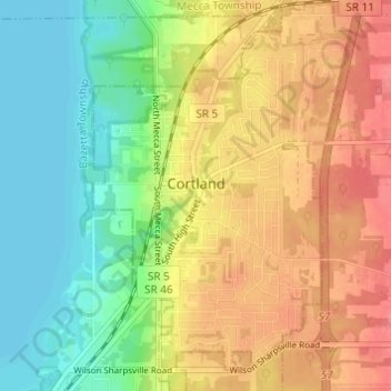
Name: Cortland topographic map, elevation, terrain.
Location: Cortland, Trumbull County, Ohio, United States (41.30575 -80.74151 41.35151 -80.70100)
Average elevation: 1,001 ft
Minimum elevation: 896 ft
Maximum elevation: 1,112 ft
Trumbull County trails, hiking, mountain biking, running and outdoor activities
Other topographic maps
Click on a map to view its topography, its elevation and its terrain.
Hakes Corners
United States > Ohio > Trumbull County > Niles > Weathersfield Township
Average elevation: 988 ft