
New Haven topographic map
Interactive map
Click on the map to display elevation.
About this map
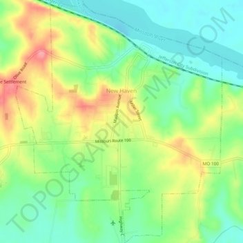
Name: New Haven topographic map, elevation, terrain.
Location: New Haven, Franklin County, Missouri, United States (38.58525 -91.23963 38.62216 -91.19947)
Average elevation: 594 ft
Minimum elevation: 466 ft
Maximum elevation: 781 ft
Franklin County trails, hiking, mountain biking, running and outdoor activities
Other topographic maps
Click on a map to view its topography, its elevation and its terrain.
Lake Saint Clair Number Three Dam
United States > Missouri > Franklin County
Average elevation: 705 ft