
Breckland District topographic map
Interactive map
Click on the map to display elevation.
About this map
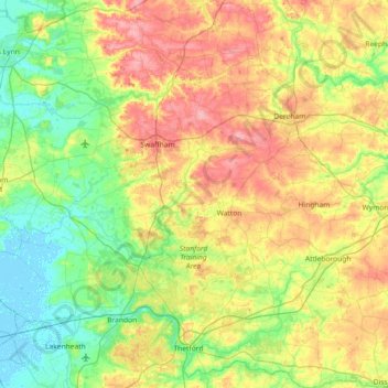
Name: Breckland District topographic map, elevation, terrain.
Location: Breckland District, Norfolk, England, United Kingdom (52.36950 0.53050 52.81110 1.10830)
Average elevation: 121 ft
Minimum elevation: -13 ft
Maximum elevation: 328 ft
Other topographic maps
Click on a map to view its topography, its elevation and its terrain.
Burn
United Kingdom > England > Norfolk > King's Lynn and West Norfolk > Burnham Overy
Average elevation: 52 ft
Brancaster Staithe
United Kingdom > England > Norfolk > King's Lynn and West Norfolk
Average elevation: 59 ft