
Wayne County topographic map
Interactive map
Click on the map to display elevation.
Wayne County
Grosse Ile is the largest island in the county and is connected to the mainland by the Wayne County Bridge and the Grosse Ile Toll Bridge. The highest elevation (990 feet (300 m)) in the county is near Northville, in Maybury State Park.
About this map
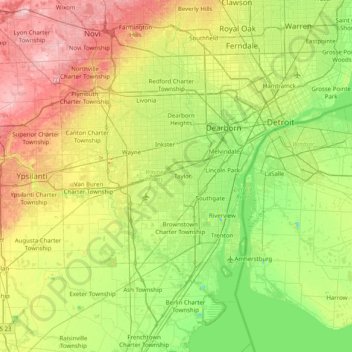
Name: Wayne County topographic map, elevation, terrain.
Location: Wayne County, Michigan, United States (42.02792 -83.55189 42.45141 -82.75011)
Average elevation: 666 ft
Minimum elevation: 453 ft
Maximum elevation: 1,060 ft
Michigan trails, hiking, mountain biking, running and outdoor activities
Other topographic maps
Click on a map to view its topography, its elevation and its terrain.
Skinnies Lake
United States > Michigan > Marquette County > Humboldt Township
Average elevation: 1,486 ft
Rawsonville
United States > Michigan > Washtenaw County > Ypsilanti Charter Township
Average elevation: 702 ft
Horseshoe Lake
United States > Michigan > Marquette County > Republic Township
Average elevation: 1,650 ft
Rawsonville
United States > Michigan > Washtenaw County > Ypsilanti Charter Township
Average elevation: 702 ft
South Fox Island
United States > Michigan > Leelanau County
North Fox Island has an operational public 3,001-foot-long by 100-foot-wide (914m x 30m) grass airstrip as of August 2023, making it accessible by general aviation. Runway 7 has a displaced threshold of 804 ft. and Runway 25 has a displaced threshold of 999 ft. Both runways have trees at their ends ranging…
Average elevation: 607 ft
Grand Mere State Park
United States > Michigan > Berrien County > Stevensville
Average elevation: 607 ft
Village of Dansville Community Park
United States > Michigan > Ingham County > Dansville
Average elevation: 948 ft
Mooreville
United States > Michigan > Washtenaw County > York Charter Township
Average elevation: 728 ft
Dollar Lake
United States > Michigan > Oakland County > Independence Charter Township
Average elevation: 1,004 ft
Charlevoix South Pier Light
United States > Michigan > Charlevoix County > Charlevoix
Average elevation: 591 ft
Hatchs
United States > Michigan > Leelanau County > Elmwood Charter Township
Average elevation: 728 ft
Grand Mere State Park
United States > Michigan > Berrien County > Stevensville
Average elevation: 607 ft
Carpenter Lake Nature Preserve
United States > Michigan > Oakland County > Southfield
Average elevation: 679 ft
Oxbow
United States > Michigan > Oakland County > White Lake Charter Township
Average elevation: 961 ft
New Hudson
United States > Michigan > Oakland County > Lyon Charter Township
Average elevation: 951 ft