
Serpent Mound topographic map
Interactive map
Click on the map to display elevation.
Serpent Mound
The mound is located on the site of a classic astrobleme, an ancient meteorite impact structure. One of the strongest clues to the impact origin of this structure is in the pattern of disruption of sedimentary strata. In the center of the structure, strata have been uplifted several hundred feet, in much the same way that the central uplifts of lunar craters such as Copernicus were formed. In 2003 geologists from Ohio State University and the University of Glasgow (Scotland) corroborated the meteorite impact origin of the structure at Serpent Mound. They had studied core samples collected at the site in the 1970s. Further analyses of the rock core samples indicated the impact occurred during the Permian Period, about 248 to 286 million years ago; thus, the topographic expression of this impact, an impact crater, has been completely erased by erosion.
About this map
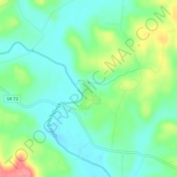
Name: Serpent Mound topographic map, elevation, terrain.
Average elevation: 741 ft
Minimum elevation: 653 ft
Maximum elevation: 938 ft
Adams County trails, hiking, mountain biking, running and outdoor activities
Other topographic maps
Click on a map to view its topography, its elevation and its terrain.
Richard and Lucile Durrell Edge of Appalachia Preserve
United States > Ohio > Adams County
Average elevation: 728 ft