
Fairfield topographic map
Interactive map
Click on the map to display elevation.
About this map
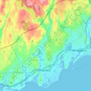
Name: Fairfield topographic map, elevation, terrain.
Average elevation: 121 ft
Minimum elevation: -26 ft
Maximum elevation: 453 ft
Connecticut trails, hiking, mountain biking, running and outdoor activities
Other topographic maps
Click on a map to view its topography, its elevation and its terrain.
Mystic
United States > Connecticut > Southeastern Connecticut Planning Region
Average elevation: 79 ft
Big Indian
United States > Connecticut > South Central Connecticut Planning Region > Guilford
Average elevation: 135 ft
The Matterhorn
United States > Connecticut > Northwest Hills Planning Region > Canaan
Average elevation: 1,516 ft
Washington Depot
United States > Connecticut > Northwest Hills Planning Region > Washington
Average elevation: 758 ft
Millville
United States > Connecticut > Naugatuck Valley Planning Region > Naugatuck
Average elevation: 433 ft
Marble Dale
United States > Connecticut > Northwest Hills Planning Region > Washington
Average elevation: 817 ft
Killingly Center
United States > Connecticut > Northeastern Connecticut Planning Region > Killingly > Dayville
Average elevation: 358 ft
Oakdale
United States > Connecticut > Southeastern Connecticut Planning Region > Montville
Average elevation: 463 ft
Hurd State Park
United States > Connecticut > Lower Connecticut River Valley Planning Region > East Hampton
Average elevation: 249 ft
King Street
United States > Connecticut > Western Connecticut Planning Region > Danbury
Average elevation: 778 ft
Taftville Reservoir #1 Dam
United States > Connecticut > Southeastern Connecticut Planning Region > Norwich
Average elevation: 246 ft
South End
United States > Connecticut > Western Connecticut Planning Region > Stamford
Average elevation: 36 ft
Quiambaug
United States > Connecticut > Southeastern Connecticut Planning Region > Mystic
Average elevation: 26 ft
Griswoldville
United States > Connecticut > Capitol Planning Region > Wethersfield
Average elevation: 112 ft
Four Corners
United States > Connecticut > Southeastern Connecticut Planning Region > Montville
Average elevation: 354 ft
Bulls Bridge
United States > Connecticut > Northwest Hills Planning Region > Kent
Average elevation: 584 ft
Spoonville
United States > Connecticut > Capitol Planning Region > East Granby
Average elevation: 203 ft
Mount Higby
United States > Connecticut > Lower Connecticut River Valley Planning Region > Middletown
Average elevation: 440 ft
Skinnerville
United States > Connecticut > Lower Connecticut River Valley Planning Region > East Hampton
Average elevation: 430 ft
Hadlyme
United States > Connecticut > Lower Connecticut River Valley Planning Region > Lyme
Average elevation: 148 ft
Minortown
United States > Connecticut > Naugatuck Valley Planning Region > Woodbury
Average elevation: 554 ft
Cottage Grove
United States > Connecticut > Capitol Planning Region > Bloomfield
Average elevation: 102 ft
Town Plot Hill
United States > Connecticut > Naugatuck Valley Planning Region > Waterbury
Average elevation: 417 ft
Unionville
United States > Connecticut > Capitol Planning Region > Farmington
Average elevation: 315 ft
Warsaw Park
United States > Connecticut > Naugatuck Valley Planning Region > Ansonia
Average elevation: 351 ft
Pleasant Valley
United States > Connecticut > Northwest Hills Planning Region > Barkhamsted
Average elevation: 630 ft
Union City
United States > Connecticut > Naugatuck Valley Planning Region > Naugatuck
Average elevation: 407 ft
East River
United States > Connecticut > South Central Connecticut Planning Region > Madison
Average elevation: 30 ft
Long Ridge
United States > Connecticut > Western Connecticut Planning Region > Stamford
Average elevation: 413 ft
Manitock Spring
United States > Connecticut > Southeastern Connecticut Planning Region > Waterford
Average elevation: 85 ft
Fenwood
United States > Connecticut > Lower Connecticut River Valley Planning Region > Old Saybrook
Average elevation: 7 ft
Forest Heights
United States > Connecticut > South Central Connecticut Planning Region > Milford
Average elevation: 62 ft
Essex
United States > Connecticut > Lower Connecticut River Valley Planning Region
Average elevation: 148 ft
Knollwood
United States > Connecticut > Lower Connecticut River Valley Planning Region > Old Saybrook
Average elevation: 7 ft
Wataba Lake
United States > Connecticut > Western Connecticut Planning Region > Ridgefield
Average elevation: 673 ft
Flanders
United States > Connecticut > Southeastern Connecticut Planning Region > East Lyme
Average elevation: 141 ft
Fort Trumbull
United States > Connecticut > South Central Connecticut Planning Region > Milford
Average elevation: 23 ft
Grove Beach
United States > Connecticut > Lower Connecticut River Valley Planning Region > Westbrook
Average elevation: 23 ft
Brightview
United States > Connecticut > South Central Connecticut Planning Region > New Haven
Average elevation: 16 ft
Chesterfield
United States > Connecticut > Southeastern Connecticut Planning Region > Montville
Average elevation: 253 ft
Byram
United States > Connecticut > Western Connecticut Planning Region > Greenwich
Average elevation: 62 ft
High Rock
United States > Connecticut > Southeastern Connecticut Planning Region > Waterford
Average elevation: 128 ft
Four Corners
United States > Connecticut > Capitol Planning Region > Terramuggus
Average elevation: 469 ft
Flanders
United States > Connecticut > Southeastern Connecticut Planning Region > East Lyme
Average elevation: 141 ft
Haystack Mountain
United States > Connecticut > Northwest Hills Planning Region > Norfolk
Average elevation: 1,263 ft
Laysville
United States > Connecticut > Lower Connecticut River Valley Planning Region > Old Lyme
Average elevation: 108 ft
West Norwalk
United States > Connecticut > Western Connecticut Planning Region > Norwalk
Average elevation: 164 ft
Bakerville
United States > Connecticut > Northwest Hills Planning Region > New Hartford
Average elevation: 801 ft
Morningside
United States > Connecticut > South Central Connecticut Planning Region > Milford
Average elevation: 16 ft
Elmville
United States > Connecticut > Northeastern Connecticut Planning Region > Killingly
Average elevation: 348 ft
Hamburg
United States > Connecticut > Lower Connecticut River Valley Planning Region > Lyme
Average elevation: 161 ft
Westview Heights
United States > Connecticut > Naugatuck Valley Planning Region > Middlebury
Average elevation: 522 ft
Cedar Land
United States > Connecticut > Naugatuck Valley Planning Region > Southbury
Average elevation: 338 ft
Deer Hill
United States > Connecticut > Western Connecticut Planning Region > Danbury
Average elevation: 443 ft
Godfrey Corner
United States > Connecticut > Western Connecticut Planning Region > Weston
Average elevation: 361 ft
Torringford
United States > Connecticut > Northwest Hills Planning Region > Torrington
Average elevation: 988 ft
Mount Carmel Center
United States > Connecticut > South Central Connecticut Planning Region > Hamden
Average elevation: 259 ft
Fox Hollow
United States > Connecticut > Naugatuck Valley Planning Region > Cheshire
Average elevation: 210 ft
Bayview
United States > Connecticut > South Central Connecticut Planning Region > Milford
Average elevation: 16 ft
Austrailia Beach
United States > Connecticut > Southeastern Connecticut Planning Region > Stonington > Mystic
Average elevation: 62 ft
Bradford Mountain
United States > Connecticut > Northwest Hills Planning Region > Canaan
Average elevation: 1,542 ft
Town Hill
United States > Connecticut > Northwest Hills Planning Region > New Hartford
Average elevation: 837 ft
South Meriden
United States > Connecticut > South Central Connecticut Planning Region > Meriden
Average elevation: 180 ft
Johnson Hill
United States > Connecticut > Capitol Planning Region > West Hartford
Average elevation: 112 ft
Arnolds
United States > Connecticut > Lower Connecticut River Valley Planning Region > Haddam
Average elevation: 236 ft
Momauguin
United States > Connecticut > South Central Connecticut Planning Region > East Haven
Average elevation: 10 ft
Chesterfield
United States > Connecticut > Southeastern Connecticut Planning Region > Montville
Average elevation: 253 ft
Uncasville
United States > Connecticut > Southeastern Connecticut Planning Region > Montville
Average elevation: 131 ft
Town Open Space (Ashford Lane)
United States > Connecticut > Western Connecticut Planning Region > Newtown
Average elevation: 656 ft
Oxford Park
United States > Connecticut > Lower Connecticut River Valley Planning Region > Cromwell
Average elevation: 105 ft
Bunker Hill
United States > Connecticut > Naugatuck Valley Planning Region > Waterbury
Average elevation: 459 ft
Center Groton
United States > Connecticut > Southeastern Connecticut Planning Region > Groton
Average elevation: 161 ft
Roxbury
United States > Connecticut > Western Connecticut Planning Region > Stamford
Average elevation: 157 ft
Quaker Hill
United States > Connecticut > Southeastern Connecticut Planning Region > Waterford
Average elevation: 115 ft
Glenville
United States > Connecticut > Western Connecticut Planning Region > Greenwich
Average elevation: 177 ft
Talcott Mountain
United States > Connecticut > Capitol Planning Region > Bloomfield
Average elevation: 499 ft
Canaan Valley
United States > Connecticut > Northwest Hills Planning Region > North Canaan
Average elevation: 961 ft
Unionville
United States > Connecticut > Capitol Planning Region > Farmington
Average elevation: 315 ft
Quinnipiac
United States > Connecticut > South Central Connecticut Planning Region > Wallingford
Average elevation: 102 ft
Northfield
United States > Connecticut > Northwest Hills Planning Region > Litchfield
Average elevation: 850 ft
North Stamford
United States > Connecticut > Western Connecticut Planning Region > Stamford
Average elevation: 292 ft
Palmers Hill
United States > Connecticut > Western Connecticut Planning Region > Stamford
Average elevation: 102 ft
Belltown
United States > Connecticut > Western Connecticut Planning Region > Stamford
Average elevation: 105 ft
North Stonington
United States > Connecticut > Southeastern Connecticut Planning Region
Average elevation: 240 ft
Mianus
United States > Connecticut > Western Connecticut Planning Region > Greenwich
Average elevation: 75 ft
Oronoque
United States > Connecticut > Greater Bridgeport Planning Region > Stratford
Average elevation: 121 ft
Ansonia
United States > Connecticut > South Central Connecticut Planning Region
Average elevation: 364 ft
Stafford Springs
United States > Connecticut > Capitol Planning Region > Stafford
Average elevation: 656 ft
Stratfield
United States > Connecticut > Greater Bridgeport Planning Region > Fairfield
Average elevation: 174 ft
Barbara Drive
United States > Connecticut > Capitol Planning Region > Windsor Locks
Average elevation: 128 ft