
Colfax topographic map
Interactive map
Click on the map to display elevation.
Colfax
Colfax has a hot-summer Mediterranean climate (Köppen Csa) that is characterized by cool, wet winters and hot, dry summers. Summers can be quite hot, especially in the months of July and August where temperatures easily reach 90 °F (32 °C), with plenty of sunshine. Winters, on the other hand, are quite cool with temperatures in December hovering around 46 °F (8 °C), and owing to its altitude above sea level, Colfax some years sees snow accumulation.
About this map
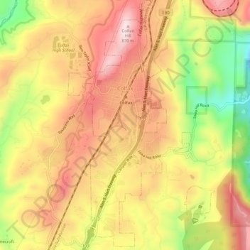
Name: Colfax topographic map, elevation, terrain.
Location: Colfax, Placer County, California, United States (39.07492 -120.96506 39.11484 -120.93491)
Average elevation: 2,247 ft
Minimum elevation: 1,450 ft
Maximum elevation: 2,822 ft
Placer County trails, hiking, mountain biking, running and outdoor activities
Other topographic maps
Click on a map to view its topography, its elevation and its terrain.
Carnelian Bay
United States > California > Placer County
For statistical purposes, the United States Census Bureau has defined Carnelian Bay as a census-designated place (CDP). The census definition of the area may not precisely correspond to local understanding of the area with the same name. The population was 524 at the 2010 census. The elevation is 6,325 feet…
Average elevation: 6,486 ft
Blue Canyon
United States > California > Placer County
Blue Canyon (also, Blue Cañon) is an unincorporated community in Placer County, California. Blue Canyon is located 4 miles (6.4 km) southwest of Emigrant Gap. It lies at an elevation of 4695 feet (1431 m).
Average elevation: 4,764 ft