
Sainte-Agathe-des-Monts topographic map
Interactive map
Click on the map to display elevation.
About this map
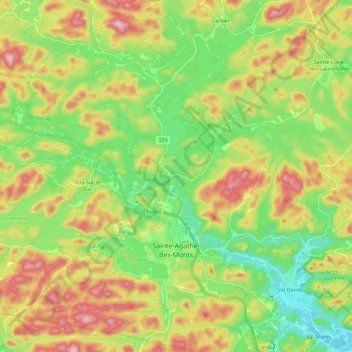
Name: Sainte-Agathe-des-Monts topographic map, elevation, terrain.
Average elevation: 1,371 ft
Minimum elevation: 994 ft
Maximum elevation: 1,932 ft
Other topographic maps
Click on a map to view its topography, its elevation and its terrain.
Lac de la Poche
Canada > Quebec > Les Laurentides > Mont-Tremblant > Lac-Tremblant-Nord
Average elevation: 981 ft
Lac Swell
Canada > Quebec > Les Laurentides > Sainte-Lucie-des-Laurentides
Average elevation: 1,427 ft
Saint-Faustin
Canada > Quebec > Les Laurentides > Saint-Faustin–Lac-Carré > Saint-Faustin-Lac-Carré
Average elevation: 1,358 ft
Lac-à-la-Truite
Canada > Quebec > Les Laurentides > Sainte-Agathe-des-Monts
Average elevation: 1,339 ft
Mont Sainte-Agathe
Canada > Quebec > Les Laurentides > Sainte-Agathe-des-Monts
Average elevation: 1,470 ft