
Kooskia topographic map
Interactive map
Click on the map to display elevation.
Kooskia
Kooskia is located at 46°8′30″N 115°58′47″W / 46.14167°N 115.97972°W / 46.14167; -115.97972 (46.139, -115.979), at an elevation of 1,293 feet (394 m) [above sea level.
About this map
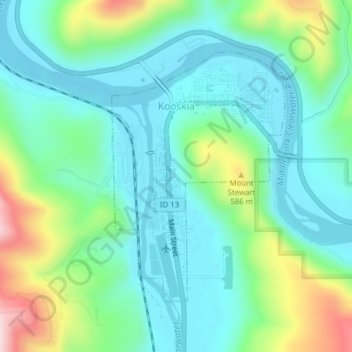
Name: Kooskia topographic map, elevation, terrain.
Location: Kooskia, Idaho County, Idaho, United States (46.12991 -115.98509 46.14908 -115.96591)
Average elevation: 1,506 ft
Minimum elevation: 1,211 ft
Maximum elevation: 2,346 ft
Idaho County trails, hiking, mountain biking, running and outdoor activities
Other topographic maps
Click on a map to view its topography, its elevation and its terrain.