
Tallulah Falls topographic map
Interactive map
Click on the map to display elevation.
About this map
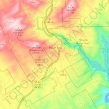
Name: Tallulah Falls topographic map, elevation, terrain.
Location: Tallulah Falls, Habersham County, Georgia, United States (34.69003 -83.41859 34.76153 -83.34676)
Average elevation: 1,601 ft
Minimum elevation: 748 ft
Maximum elevation: 2,356 ft
Other topographic maps
Click on a map to view its topography, its elevation and its terrain.
Tugaloo
United States > Georgia > Habersham County > Tallulah Falls
Tugaloo, Tallulah Falls, Habersham County, Georgia, United States
Average elevation: 1,286 ft
Turnerville
United States > Georgia > Habersham County
Turnerville, Habersham County, Georgia, 30580, United States
Average elevation: 1,519 ft
Habersham
United States > Georgia > Habersham County
Habersham, Habersham County, Georgia, 30544, United States
Average elevation: 1,342 ft
Baldwin
United States > Georgia > Habersham County
Baldwin, Habersham County, Georgia, United States
Average elevation: 1,296 ft
Clarkesville
United States > Georgia > Habersham County
Clarkesville, Habersham County, Georgia, United States
Average elevation: 1,371 ft
Mount Airy
United States > Georgia > Habersham County
Mount Airy, Habersham County, Georgia, United States
Average elevation: 1,453 ft
Demorest
United States > Georgia > Habersham County
Demorest, Habersham County, Georgia, United States
Average elevation: 1,365 ft
Apple Pie Mountain
United States > Georgia > Habersham County
Apple Pie Mountain, Habersham County, Georgia, 30573, United States
Average elevation: 1,762 ft
Cornelia
United States > Georgia > Habersham County
Cornelia, Habersham County, Georgia, United States
Average elevation: 1,463 ft