
Dunwoody topographic map
Interactive map
Click on the map to display elevation.
About this map
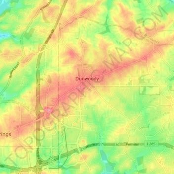
Name: Dunwoody topographic map, elevation, terrain.
Location: Dunwoody, DeKalb County, Georgia, United States (33.91500 -84.34793 33.97087 -84.26493)
Average elevation: 1,027 ft
Minimum elevation: 833 ft
Maximum elevation: 1,201 ft
DeKalb County trails, hiking, mountain biking, running and outdoor activities
Other topographic maps
Click on a map to view its topography, its elevation and its terrain.
Stone Mountain
United States > Georgia > DeKalb County
The park is owned by the state of Georgia and is currently managed by Herschend Family Entertainment. At its summit, the elevation is 1,686 feet (514 m) above sea level and 825 feet (251 m) above the surrounding area. Stone Mountain is well known for not only its geology, but also the enormous rock relief on…
Average elevation: 981 ft