
Make a donation
Gear up for your next adventure:
As an Amazon Associate, this site earns from qualifying purchases at no extra cost to you.
North Cascades National Park topographic map
Click on the map to display elevation.
Make a donation
Gear up for your next adventure:
As an Amazon Associate, this site earns from qualifying purchases at no extra cost to you.
North Cascades National Park
More than 500 lakes and ponds are located within North Cascades National Park. Many of these are devoid of fish, not uncommon in steep terrain where fish may not be able to access high altitude waterways. Around 240 of these lakes exist in the higher elevations and stocking of some of these lakes with fish has been ongoing since the late 19th century. Fishing in these lakes, which, without fish stocking, do not have native fish, is part of the area's economy and tourism. In 2008 an Environmental Impact Statement was produced that examined whether these lakes should continue to be stocked, and if so, what the impact would be on native species such as salamanders and other aquatic life. The North Cascades National Park Service Complex Fish Stocking Act, signed in 2014, directs the NPS to allow stocking of non-reproducing fish in no more than 42 lakes, making it the only national park to continue to stock non-native fish in park lakes. The prior decision not to continue to stock the lakes with fish was part of a larger debate about what "natural" means in reference to national parks.
Make a donation
Gear up for your next adventure:
As an Amazon Associate, this site earns from qualifying purchases at no extra cost to you.
About this map
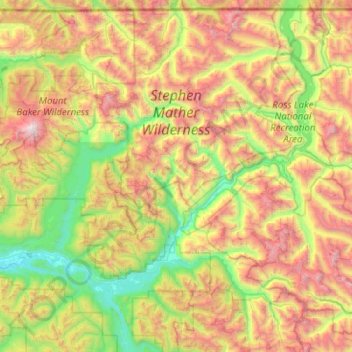
Name: North Cascades National Park topographic map, elevation, terrain.
Average elevation: 3,773 ft
Minimum elevation: 112 ft
Maximum elevation: 10,722 ft
Whatcom County trails, hiking, mountain biking, running and outdoor activities
Make a donation
Gear up for your next adventure:
As an Amazon Associate, this site earns from qualifying purchases at no extra cost to you.
Other topographic maps
Click on a map to view its topography, its elevation and its terrain.
Make a donation
Gear up for your next adventure:
As an Amazon Associate, this site earns from qualifying purchases at no extra cost to you.
Make a donation
Gear up for your next adventure:
As an Amazon Associate, this site earns from qualifying purchases at no extra cost to you.
Mount Redoubt
United States > Washington > Whatcom County
The North Cascades features some of the most rugged topography in the Cascade Range with craggy peaks, spires, ridges, and deep glacial valleys. Geological events occurring many years ago created the diverse topography and drastic elevation changes over the Cascade Range leading to the various climate…
Average elevation: 6,791 ft
Make a donation
Gear up for your next adventure:
As an Amazon Associate, this site earns from qualifying purchases at no extra cost to you.
Make a donation
Gear up for your next adventure:
As an Amazon Associate, this site earns from qualifying purchases at no extra cost to you.
Bellingham
United States > Washington > Whatcom County > Bellingham
According to the United States Census Bureau, the city has a total area of 28.90 square miles (74.85 km2), of which, 27.08 square miles (70.14 km2) is land and 1.82 square miles (4.71 km2) is water. The lowest elevations are at sea level along the waterfront. Alabama Hill is one of the higher points in the…
Average elevation: 423 ft
Make a donation
Gear up for your next adventure:
As an Amazon Associate, this site earns from qualifying purchases at no extra cost to you.