
Mount Baker topographic map
Click on the map to display elevation.
About this map
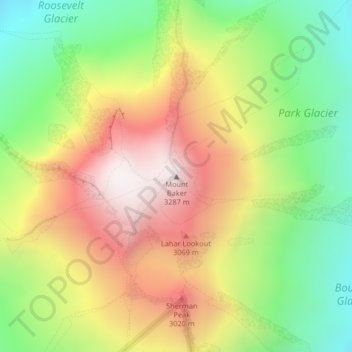
Name: Mount Baker topographic map, elevation, terrain.
Location: Mount Baker, Whatcom County, Washington, United States (48.77672 -121.81462 48.77682 -121.81452)
Average elevation: 8,855 ft
Minimum elevation: 7,159 ft
Maximum elevation: 10,741 ft
Whatcom County trails, hiking, mountain biking, running and outdoor activities
Other topographic maps
Click on a map to view its topography, its elevation and its terrain.
Bellingham
United States > Washington > Whatcom County
Bellingham is characterized by a diverse and striking topography that combines coastal and mountainous landscapes. The city lies along the eastern shore of Bellingham Bay, where the waters of the Puget Sound meet the foothills of the Cascade Range. Rising abruptly from the shoreline, the surrounding hills and…
Average elevation: 292 ft
North Cascades National Park
United States > Washington > Whatcom County
More than 500 lakes and ponds are located within North Cascades National Park. Many of these are devoid of fish, not uncommon in steep terrain where fish may not be able to access high altitude waterways. Around 240 of these lakes exist in the higher elevations and stocking of some of these lakes with fish has…
Average elevation: 3,773 ft
Bellingham
United States > Washington > Whatcom County
According to the United States Census Bureau, the city has a total area of 28.90 square miles (74.85 km2), of which, 27.08 square miles (70.14 km2) is land and 1.82 square miles (4.71 km2) is water. The lowest elevations are at sea level along the waterfront. Alabama Hill is one of the higher points in the…
Average elevation: 292 ft
Diablo Lake
United States > Washington > Whatcom County
Diablo Lake is a reservoir in the North Cascade mountains of northern Washington state, United States. Created by Diablo Dam, the lake is located between Ross Lake and Gorge Lake on the Skagit River at an elevation of 1,201 feet (366 m) above sea level. Diablo Lake is part of the Skagit River Hydroelectric…
Average elevation: 2,110 ft
Bellingham
United States > Washington > Whatcom County
According to the United States Census Bureau, the city has a total area of 30.511 square miles (79.02 km2), of which, 28.198 square miles (73.03 km2) is land and 2.313 square miles (5.99 km2) is water. The lowest elevations are at sea level along the waterfront. Alabama Hill is one of the higher points in the…
Average elevation: 292 ft
Ross Lake
United States > Washington > Whatcom County
Ross Lake is a large reservoir in the North Cascade mountains of northern Washington state, United States, and southwestern British Columbia, Canada. The lake runs approximately north–south, is 23 miles (37 km) long, up to 1.5 miles (2.5 km) wide, and the full reservoir elevation is 1,604 feet above sea…
Average elevation: 4,311 ft
Bellingham
United States > Washington > Whatcom County
According to the United States Census Bureau, the city has a total area of 30.511 square miles (79.02 km2), of which, 28.198 square miles (73.03 km2) is land and 2.313 square miles (5.99 km2) is water. The lowest elevations are at sea level along the waterfront. Alabama Hill is one of the higher points in the…
Average elevation: 292 ft