
Buffalo Bayou topographic map
Interactive map
Click on the map to display elevation.
Buffalo Bayou
The Buffalo Bayou watershed is central to the drainage of Houston and Harris County. Lying over relatively impervious soils and very flat topography, the bayou has extensive natural floodplains, as do most Gulf coastal rivers and streams. Urbanization of the watershed has placed thousands of people in vulnerable areas and has affected the frequency and intensity of flood events.
About this map
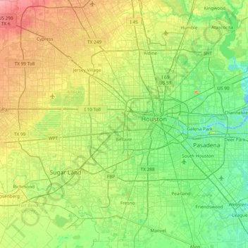
Name: Buffalo Bayou topographic map, elevation, terrain.
Location: Buffalo Bayou, Harris County, Texas, United States (29.71662 -95.82648 29.77394 -95.07929)
Average elevation: 79 ft
Minimum elevation: -7 ft
Maximum elevation: 253 ft
Harris County trails, hiking, mountain biking, running and outdoor activities
Other topographic maps
Click on a map to view its topography, its elevation and its terrain.