
Make a donation
Gear up for your next adventure:
As an Amazon Associate, this site earns from qualifying purchases at no extra cost to you.
Florida Keys topographic map
Click on the map to display elevation.
Make a donation
Gear up for your next adventure:
As an Amazon Associate, this site earns from qualifying purchases at no extra cost to you.
Florida Keys
The Florida Keys, an archipelago extending about 120 miles from the southeastern tip of Florida, feature a unique topography characterized by low-lying coral islands and a series of intricate waterways. Most islands are less than 5 feet above sea level, contributing to their vulnerability to storm surges and flooding during hurricanes. The Keys are primarily formed of limestone, shaped over thousands of years through coral growth and erosion, and are punctuated by areas of mangroves and sandy beaches. The terrain is often described as flat and delicate, with numerous small islands connected by a network of bridges, including the notable Seven Mile Bridge. This geographical layout not only enhances the natural beauty of the region but also creates a rich habitat for diverse marine life, making the Florida Keys a vital ecological zone.
Make a donation
Gear up for your next adventure:
As an Amazon Associate, this site earns from qualifying purchases at no extra cost to you.
About this map
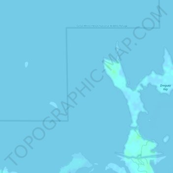
Name: Florida Keys topographic map, elevation, terrain.
Location: Florida Keys, Monroe County, Florida, United States (24.66704 -81.58319 24.66714 -81.58309)
Average elevation: 0 ft
Minimum elevation: -7 ft
Maximum elevation: 16 ft
Monroe County trails, hiking, mountain biking, running and outdoor activities
Make a donation
Gear up for your next adventure:
As an Amazon Associate, this site earns from qualifying purchases at no extra cost to you.
Other topographic maps
Click on a map to view its topography, its elevation and its terrain.
Make a donation
Gear up for your next adventure:
As an Amazon Associate, this site earns from qualifying purchases at no extra cost to you.
Make a donation
Gear up for your next adventure:
As an Amazon Associate, this site earns from qualifying purchases at no extra cost to you.
Make a donation
Gear up for your next adventure:
As an Amazon Associate, this site earns from qualifying purchases at no extra cost to you.
Make a donation
Gear up for your next adventure:
As an Amazon Associate, this site earns from qualifying purchases at no extra cost to you.