
Make a donation
Gear up for your next adventure:
As an Amazon Associate, this site earns from qualifying purchases at no extra cost to you.
Eaton County topographic map
Click on the map to display elevation.
Make a donation
Gear up for your next adventure:
As an Amazon Associate, this site earns from qualifying purchases at no extra cost to you.
About this map
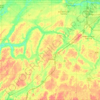
Name: Eaton County topographic map, elevation, terrain.
Location: Eaton County, Michigan, United States (42.42145 -85.07558 42.77073 -84.60042)
Average elevation: 896 ft
Minimum elevation: 797 ft
Maximum elevation: 1,004 ft
Michigan trails, hiking, mountain biking, running and outdoor activities
Make a donation
Gear up for your next adventure:
As an Amazon Associate, this site earns from qualifying purchases at no extra cost to you.
Other topographic maps
Click on a map to view its topography, its elevation and its terrain.
Golfcrest
United States > Michigan > Monroe County > Frenchtown Charter Township
Average elevation: 594 ft
Make a donation
Gear up for your next adventure:
As an Amazon Associate, this site earns from qualifying purchases at no extra cost to you.
Sunset Point
United States > Michigan > Muskegon County > Blue Lake Township
Average elevation: 653 ft
Whitefish Point
United States > Michigan > Chippewa County > Whitefish Township
Average elevation: 587 ft
Make a donation
Gear up for your next adventure:
As an Amazon Associate, this site earns from qualifying purchases at no extra cost to you.
Mcnearney Lake
United States > Michigan > Chippewa County > Bay Mills Township
Average elevation: 938 ft
Make a donation
Gear up for your next adventure:
As an Amazon Associate, this site earns from qualifying purchases at no extra cost to you.
Felch Mountain
United States > Michigan > Dickinson County > Felch Township > Felch
Average elevation: 1,161 ft
Make a donation
Gear up for your next adventure:
As an Amazon Associate, this site earns from qualifying purchases at no extra cost to you.
Christie Lake
United States > Michigan > Van Buren County > Lawrence Township
Average elevation: 781 ft
Make a donation
Gear up for your next adventure:
As an Amazon Associate, this site earns from qualifying purchases at no extra cost to you.
Make a donation
Gear up for your next adventure:
As an Amazon Associate, this site earns from qualifying purchases at no extra cost to you.
Lake Margrethe
United States > Michigan > Crawford County > Grayling Charter Township
Average elevation: 1,181 ft
Old Mission
United States > Michigan > Grand Traverse County
Old Mission is located just east of M-37 near the tip of Old Mission Peninsula about 16 miles (25.75 km) north of Traverse City. The community was built along Old Mission Harbor, which is a small safe haven along the East Arm of Grand Traverse Bay. The community sits at an elevation of 587 feet (179 m) above…
Average elevation: 623 ft
Make a donation
Gear up for your next adventure:
As an Amazon Associate, this site earns from qualifying purchases at no extra cost to you.
Limestone Mountain
United States > Michigan > Houghton County > Laird Township
Average elevation: 804 ft
Saint Martin Island
United States > Michigan > Delta County > Fairbanks Township
Average elevation: 591 ft
Make a donation
Gear up for your next adventure:
As an Amazon Associate, this site earns from qualifying purchases at no extra cost to you.
Matchwood
United States > Michigan > Ontonagon County > Matchwood Township
Average elevation: 1,230 ft
Make a donation
Gear up for your next adventure:
As an Amazon Associate, this site earns from qualifying purchases at no extra cost to you.
Merriweather
United States > Michigan > Ontonagon County > Bergland Township
Average elevation: 1,339 ft
Make a donation
Gear up for your next adventure:
As an Amazon Associate, this site earns from qualifying purchases at no extra cost to you.
Boyne Mountain
United States > Michigan > Charlevoix County > Boyne Valley Township
Average elevation: 863 ft
Make a donation
Gear up for your next adventure:
As an Amazon Associate, this site earns from qualifying purchases at no extra cost to you.
Metamora-Hadley State Recreation Area
United States > Michigan > Lapeer County > Metamora
Average elevation: 978 ft
Rawsonville
United States > Michigan > Washtenaw County > Ypsilanti Charter Township
Average elevation: 702 ft
Make a donation
Gear up for your next adventure:
As an Amazon Associate, this site earns from qualifying purchases at no extra cost to you.
Falmouth
United States > Michigan > Missaukee County > Clam Union Township
Average elevation: 1,191 ft
Lookout Point
United States > Michigan > Grand Traverse County > Peninsula Township
Average elevation: 617 ft
Make a donation
Gear up for your next adventure:
As an Amazon Associate, this site earns from qualifying purchases at no extra cost to you.
Shattuckville
United States > Michigan > Saginaw County > Saginaw Charter Township
Average elevation: 614 ft
Make a donation
Gear up for your next adventure:
As an Amazon Associate, this site earns from qualifying purchases at no extra cost to you.
Anchor Bay Shores
United States > Michigan > Macomb County > Chesterfield Township
Average elevation: 577 ft
Make a donation
Gear up for your next adventure:
As an Amazon Associate, this site earns from qualifying purchases at no extra cost to you.
Preston Corners
United States > Michigan > Macomb County > Shelby Charter Township
Average elevation: 650 ft
Make a donation
Gear up for your next adventure:
As an Amazon Associate, this site earns from qualifying purchases at no extra cost to you.
Mount Baldhead
United States > Michigan > Allegan County > Saugatuck
Mount Baldhead, also known as Mt. Baldy and Radar Hill, is a 250-foot (76-meter) sand dune located on a narrow strip of land between Lake Michigan and Kalamazoo River, directly across the river from downtown Saugatuck. It has an elevation of 807 feet (246 meters) and is about 70 miles (110 kilometers) north of…
Average elevation: 604 ft
Diamond Park
United States > Michigan > Grand Traverse County > Green Lake Township
Average elevation: 837 ft
Make a donation
Gear up for your next adventure:
As an Amazon Associate, this site earns from qualifying purchases at no extra cost to you.
Hulbert
United States > Michigan > Chippewa County > Hulbert Township
Hulbert is a rural community in western Chippewa County in the Upper Peninsula. The community is located within Hulbert Township about 40 miles (64 km) south of the Tahquamenon Falls. The community sits at an elevation of 751 feet (229 m) above sea level.
Average elevation: 758 ft
Maple Grove Corners
United States > Michigan > Van Buren County > South Haven Charter Township
Average elevation: 646 ft
Make a donation
Gear up for your next adventure:
As an Amazon Associate, this site earns from qualifying purchases at no extra cost to you.
Sucker Creek
United States > Michigan > Ontonagon County > McMillan Township
Average elevation: 1,191 ft
Shattuckville
United States > Michigan > Saginaw County > Saginaw Charter Township
Average elevation: 614 ft
Make a donation
Gear up for your next adventure:
As an Amazon Associate, this site earns from qualifying purchases at no extra cost to you.
Drum Lake
United States > Michigan > Presque Isle County > Bismarck Township
Average elevation: 833 ft
Make a donation
Gear up for your next adventure:
As an Amazon Associate, this site earns from qualifying purchases at no extra cost to you.
Long Point Bay
United States > Michigan > Saint Clair County > Clay Township
Average elevation: 571 ft
Echo Lake
United States > Michigan > Kent County > Grand Rapids Charter Township
Average elevation: 787 ft
Grand Mere State Park
United States > Michigan > Berrien County > Lincoln Charter Township
Average elevation: 607 ft
Make a donation
Gear up for your next adventure:
As an Amazon Associate, this site earns from qualifying purchases at no extra cost to you.
Falmouth
United States > Michigan > Missaukee County > Clam Union Township
Average elevation: 1,191 ft
Cranberry Lake
United States > Michigan > Oakland County > White Lake Charter Township
Average elevation: 968 ft
Make a donation
Gear up for your next adventure:
As an Amazon Associate, this site earns from qualifying purchases at no extra cost to you.
North Farmington
United States > Michigan > Oakland County > Farmington Hills
Average elevation: 909 ft
Make a donation
Gear up for your next adventure:
As an Amazon Associate, this site earns from qualifying purchases at no extra cost to you.
Lower Peninsula Experimental Forest
United States > Michigan > Wexford County > South Branch Township
Average elevation: 1,030 ft
Mullet Lake Village Boating Access Site
United States > Michigan > Cheboygan County > Inverness Township
Average elevation: 607 ft
Van Riper State Park
United States > Michigan > Marquette County > Michigamme Township
Average elevation: 1,604 ft
Mount Arvon
United States > Michigan > Baraga County > L'Anse Township
Mount Arvon (/ɑːrvɒn/ ARR-vahn) at 1,979 feet (603 m), is the highest natural point in the U.S. state of Michigan. Located in L'Anse Township, Baraga County, Mount Arvon is part of the Huron Mountains. It rises about eight miles (13 km) south of Lake Superior (elevation 591 feet [180 m]). On the list of…
Average elevation: 1,726 ft
Make a donation
Gear up for your next adventure:
As an Amazon Associate, this site earns from qualifying purchases at no extra cost to you.
Clyde
United States > Michigan > Oakland County > Highland Charter Township
Average elevation: 1,033 ft
Make a donation
Gear up for your next adventure:
As an Amazon Associate, this site earns from qualifying purchases at no extra cost to you.