
Jepara topographic map
Interactive map
Click on the map to display elevation.
About this map
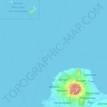
Name: Jepara topographic map, elevation, terrain.
Location: Jepara, Central Java, Indonesia (-6.79636 110.16308 -5.72581 110.97703)
Average elevation: 72 ft
Minimum elevation: 0 ft
Maximum elevation: 4,865 ft
Other topographic maps
Click on a map to view its topography, its elevation and its terrain.
Green Ambarawa Residence
Indonesia > Central Java > Kabupaten Semarang > Banyubiru
Average elevation: 1,549 ft
Gantangan Burung Bung Karno Dukuh Salatiga
Indonesia > Central Java > Salatiga > Dukuh > Glogolan
Average elevation: 1,965 ft
Perumahan Griya Mustika Jati
Indonesia > Central Java > Kabupaten Semarang > Ambarawa
Average elevation: 1,745 ft
kandangserang Selatan
Indonesia > Central Java > Pekalongan > Kandangserang
Average elevation: 1,335 ft
Menara Pandang Teratai Purwokerto
Indonesia > Central Java > Banyumas > Purwokerto
Average elevation: 240 ft