
Dingle topographic map
Interactive map
Click on the map to display elevation.
About this map
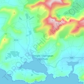
Name: Dingle topographic map, elevation, terrain.
Average elevation: 397 ft
Minimum elevation: 0 ft
Maximum elevation: 2,087 ft
Other topographic maps
Click on a map to view its topography, its elevation and its terrain.
Great Skellig
Great Skellig, Kenmare Municipal District, County Kerry, Munster, Ireland
Average elevation: 3 ft
Killarney
Killarney, Killarney Municipal District, County Kerry, Munster, Ireland
Average elevation: 187 ft
Brick
Brick, Lixnaw ED, Listowel Municipal District, County Kerry, Munster, Ireland
Average elevation: 16 ft
Caher
Caher, Kenmare Municipal District, County Kerry, Munster, V93 A8N1, Ireland
Average elevation: 2,024 ft
Kenmare Municipal District
Kenmare Municipal District, County Kerry, Munster, Ireland
Average elevation: 322 ft
Tralee
Ireland > County Kerry > Tralee
Tralee, Tralee Municipal District, County Kerry, Munster, Ireland
Average elevation: 66 ft
Brick
Brick, Lixnaw ED, Listowel Municipal District, County Kerry, Munster, Ireland
Average elevation: 16 ft
Carrauntoohil
Carrauntoohil, Kenmare Municipal District, County Kerry, Munster, V93 A8N1, Ireland
Average elevation: 2,113 ft