
Rogersville topographic map
Interactive map
Click on the map to display elevation.
About this map
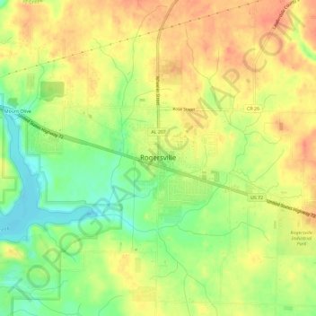
Name: Rogersville topographic map, elevation, terrain.
Location: Rogersville, Lauderdale County, Alabama, United States (34.81072 -87.30745 34.84018 -87.24943)
Average elevation: 646 ft
Minimum elevation: 551 ft
Maximum elevation: 719 ft
Lauderdale County trails, hiking, mountain biking, running and outdoor activities
Other topographic maps
Click on a map to view its topography, its elevation and its terrain.