
Zhengzhou topographic map
Interactive map
Click on the map to display elevation.
About this map
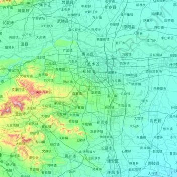
Name: Zhengzhou topographic map, elevation, terrain.
Location: Zhengzhou, 金水区, Henan, China (34.26292 112.71421 34.98775 114.20545)
Average elevation: 531 ft
Minimum elevation: 174 ft
Maximum elevation: 4,701 ft
Other topographic maps
Click on a map to view its topography, its elevation and its terrain.
Anyang
Anyang spans a total area of 7,355 square kilometres (2,840 sq mi). The city's elevation is generally higher in the west, with the foothills of the Taihang Mountains running through the area, and lower in the east, which comprises part of the North China Plain.
Average elevation: 335 ft