
Make a donation
Gear up for your next adventure:
As an Amazon Associate, this site earns from qualifying purchases at no extra cost to you.
Quảng Trị Province topographic map
Click on the map to display elevation.
Make a donation
Gear up for your next adventure:
As an Amazon Associate, this site earns from qualifying purchases at no extra cost to you.
About this map
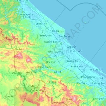
Name: Quảng Trị Province topographic map, elevation, terrain.
Location: Quảng Trị Province, Vietnam (16.30219 106.51430 17.52702 107.69197)
Average elevation: 630 ft
Minimum elevation: -7 ft
Maximum elevation: 5,604 ft
Make a donation
Gear up for your next adventure:
As an Amazon Associate, this site earns from qualifying purchases at no extra cost to you.
Other topographic maps
Click on a map to view its topography, its elevation and its terrain.
Ho Chi Minh City
Ho Chi Minh City is located in the south-eastern region of Vietnam, 1,760 km (1,090 mi) south of Hanoi. The average elevation is 5 m (16 ft) above sea level for the city center and 16 m (52 ft) for the suburb areas. It borders Tây Ninh Province and Bình Dương Province to the north, Đồng Nai Province and…
Average elevation: 20 ft
Make a donation
Gear up for your next adventure:
As an Amazon Associate, this site earns from qualifying purchases at no extra cost to you.
Sa Pa
Vietnam > Lao Cai province > Sa Pa
Sa Pa District is in Lào Cai Province, northwest Vietnam, 380 km northwest of Hanoi close to the border with China. The Hoàng Liên Son range of mountains dominates the district, which is at the eastern extremity of the Himalayas. This range includes Vietnam's highest mountain, Fan Si Pan, at a height of…
Average elevation: 4,987 ft
Make a donation
Gear up for your next adventure:
As an Amazon Associate, this site earns from qualifying purchases at no extra cost to you.
Make a donation
Gear up for your next adventure:
As an Amazon Associate, this site earns from qualifying purchases at no extra cost to you.
Da Nang
Geologically, Da Nang is at the edge of a Paleozoic fold belt known as the Truong Son Orogenic Zone, whose main deformation occurred during the early Carboniferous period. Da Nang's topography is dominated by the steep Annamite Range to the north and north-west, which features peaks ranging from 700 to 1,500 m…
Average elevation: 171 ft
Make a donation
Gear up for your next adventure:
As an Amazon Associate, this site earns from qualifying purchases at no extra cost to you.
Make a donation
Gear up for your next adventure:
As an Amazon Associate, this site earns from qualifying purchases at no extra cost to you.
Sông Vàm Cỏ Đông
Vietnam > Long An province > Cần Đước District > Xã Phước Tuy
Average elevation: 7 ft
Make a donation
Gear up for your next adventure:
As an Amazon Associate, this site earns from qualifying purchases at no extra cost to you.
Make a donation
Gear up for your next adventure:
As an Amazon Associate, this site earns from qualifying purchases at no extra cost to you.
Make a donation
Gear up for your next adventure:
As an Amazon Associate, this site earns from qualifying purchases at no extra cost to you.
Fansipan Mountain
Vietnam > Lao Cai province > Tân Uyên District > Sa Pa
Fansipan is the tallest mountain in the Hoang Lien Son Range, situated on the border of Hải Châu Province and Lai Châu Province with its peak located on the Lào Cai side. The mountain is part of the Hoàng Liên National Park. It has a topographic prominence of 1,613 metres (5,292 ft), ranking 6th in Vietnam.
Average elevation: 8,583 ft
Make a donation
Gear up for your next adventure:
As an Amazon Associate, this site earns from qualifying purchases at no extra cost to you.
Make a donation
Gear up for your next adventure:
As an Amazon Associate, this site earns from qualifying purchases at no extra cost to you.
Make a donation
Gear up for your next adventure:
As an Amazon Associate, this site earns from qualifying purchases at no extra cost to you.
Make a donation
Gear up for your next adventure:
As an Amazon Associate, this site earns from qualifying purchases at no extra cost to you.
quang truong dai doan ket
Vietnam > Gia Lai Province > Phường Pleiku > Pleiku Ward
Average elevation: 2,477 ft
Make a donation
Gear up for your next adventure:
As an Amazon Associate, this site earns from qualifying purchases at no extra cost to you.
Make a donation
Gear up for your next adventure:
As an Amazon Associate, this site earns from qualifying purchases at no extra cost to you.
Make a donation
Gear up for your next adventure:
As an Amazon Associate, this site earns from qualifying purchases at no extra cost to you.
Make a donation
Gear up for your next adventure:
As an Amazon Associate, this site earns from qualifying purchases at no extra cost to you.
Fansipan Mountain
Vietnam > Lao Cai province > Sa Pa > Xã Hoàng Liên
Fansipan is the tallest mountain in the Hoang Lien Son Range, situated on the border of Lào Cai Province and Lai Châu Province with its peak located on the Lào Cai side. The mountain is part of the Hoàng Liên National Park. It has a topographic prominence of 1,613 metres (5,292 ft), ranking 6th in Vietnam.
Average elevation: 8,583 ft
Make a donation
Gear up for your next adventure:
As an Amazon Associate, this site earns from qualifying purchases at no extra cost to you.
Southwest Cay
Vietnam > Khanh Hoa province > Trường Sa District > Xã Song Tử Tây
Average elevation: 0 ft
Make a donation
Gear up for your next adventure:
As an Amazon Associate, this site earns from qualifying purchases at no extra cost to you.
Make a donation
Gear up for your next adventure:
As an Amazon Associate, this site earns from qualifying purchases at no extra cost to you.
Yersin Park
Vietnam > Lâm Đồng Province > Phường Xuân Hương - Đà Lạt > Da Lat
Average elevation: 4,862 ft
Make a donation
Gear up for your next adventure:
As an Amazon Associate, this site earns from qualifying purchases at no extra cost to you.
Fansipan Mountain Peak
Vietnam > Lai Chau province > Xã Mường Khoa
Fansipan is the tallest mountain in the Hoang Lien Son range, situated on the border of Lào Cai and Lai Châu provinces, with its peak located on the Lào Cai side. The mountain is part of Hoàng Liên National Park. It has a topographic prominence of 1,617 metres (5,305 ft), ranking sixth in Vietnam.
Average elevation: 8,583 ft
Make a donation
Gear up for your next adventure:
As an Amazon Associate, this site earns from qualifying purchases at no extra cost to you.
Make a donation
Gear up for your next adventure:
As an Amazon Associate, this site earns from qualifying purchases at no extra cost to you.
Sông Lại Giang
Vietnam > Gia Lai Province > Phường Hoài Nhơn Nam > Khu phố Vĩnh Phụng 2
Average elevation: 148 ft
Make a donation
Gear up for your next adventure:
As an Amazon Associate, this site earns from qualifying purchases at no extra cost to you.
Make a donation
Gear up for your next adventure:
As an Amazon Associate, this site earns from qualifying purchases at no extra cost to you.
Huế
Vietnam > Huế > Thuận Hóa Ward
The Perfume River (called Sông Hương or Hương Giang in Vietnamese) passes through the center of the city. The city also accommodates the Tam Giang–Cau Hai lagoon, the largest lagoon in Southeast Asia, which is 68 kilometres (42 mi) long with a surface area of 220 square kilometres (85 sq mi). The city…
Average elevation: 98 ft
Make a donation
Gear up for your next adventure:
As an Amazon Associate, this site earns from qualifying purchases at no extra cost to you.