
North District topographic map
Interactive map
Click on the map to display elevation.
About this map
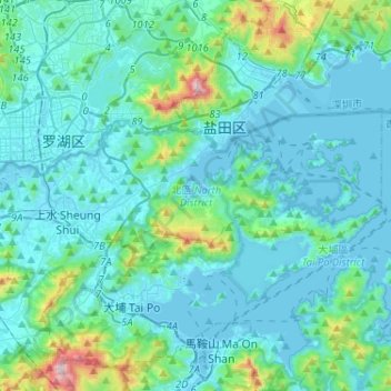
Name: North District topographic map, elevation, terrain.
Location: North District, New Territories, Hong Kong, China (22.46568 114.07833 22.56833 114.33618)
Average elevation: 377 ft
Minimum elevation: -13 ft
Maximum elevation: 3,104 ft
Other topographic maps
Click on a map to view its topography, its elevation and its terrain.
Chuen Lung Cha Tau Wo
China > Hong Kong > Tsuen Wan District > Chuen Lung Village
Average elevation: 1,319 ft
Tai Lam Chung Catchwater Section M
China > Hong Kong > Tsuen Wan District > Sham Tseng Sun Tsuen
Average elevation: 594 ft
Hong Kong
Hong Kong has a humid subtropical climate (Köppen Cwa), characteristic of southern China. Summer is hot and humid, with occasional showers and thunderstorms and warm air from the southwest. Typhoons occur most often then, sometimes resulting in floods or landslides. Winters are mild and usually sunny at the…
Average elevation: 203 ft
Shui Tsan Tin
China > Hong Kong > Yuen Long District > Lin Fa Tei > Shui Tsan Tin
Average elevation: 233 ft