
Maynard topographic map
Interactive map
Click on the map to display elevation.
About this map
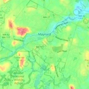
Name: Maynard topographic map, elevation, terrain.
Average elevation: 213 ft
Minimum elevation: 125 ft
Maximum elevation: 367 ft
According to the United States Census Bureau, the town has a total area of 5.4 square miles (13.9 km²), of which 5.2 square miles (13.6 km²) is land and 0.1 square miles (0.3 km²), or 2.42%, is water. Average elevation is roughly 200 feet (~61 m) above sea level; the highest point is Summer Hill, elevation 358 feet (109.1 m); the lowest is the Maynard/Acton border next to the Assabet River, at 145 feet (44.2 m).
Other topographic maps
Click on a map to view its topography, its elevation and its terrain.
Lexington
United States > Massachusetts > Middlesex County
Lexington, Middlesex County, Massachusetts, United States
Average elevation: 203 ft
Lowell
United States > Massachusetts > Middlesex County
Lowell, Middlesex County, Massachusetts, United States
Average elevation: 138 ft
Medford
United States > Massachusetts > Middlesex County
Medford, Middlesex County, Massachusetts, 02155, United States
Average elevation: 75 ft
Framingham
United States > Massachusetts > Middlesex County
Framingham, Middlesex County, Massachusetts, United States
Average elevation: 230 ft
Winchester
United States > Massachusetts > Middlesex County
Winchester, Middlesex County, Massachusetts, 01890, United States
Average elevation: 125 ft
Somerville
United States > Massachusetts > Middlesex County
Somerville, Middlesex County, Massachusetts, United States
Average elevation: 36 ft
Hopkinton
United States > Massachusetts > Middlesex County > Hopkinton
Hopkinton, Middlesex County, Massachusetts, 01748, United States
Average elevation: 358 ft
Woburn
United States > Massachusetts > Middlesex County
Woburn, Middlesex County, Massachusetts, 01801, United States
Average elevation: 131 ft
Marlborough
United States > Massachusetts > Middlesex County
Marlborough, Middlesex County, Massachusetts, United States
Average elevation: 312 ft
Melrose
United States > Massachusetts > Middlesex County
Melrose, Middlesex County, Massachusetts, 02176, United States
Average elevation: 125 ft
Fuller Heights
United States > Massachusetts > Middlesex County > Lexington
Fuller Heights, Lexington, Middlesex County, Massachusetts, 02420, United States
Average elevation: 217 ft
Saxonville
United States > Massachusetts > Middlesex County > Framingham
Saxonville, Framingham, Middlesex County, Massachusetts, 01701, United States
Average elevation: 174 ft
Pine Lake
United States > Massachusetts > Middlesex County > Sudbury
Pine Lake, Sudbury, Middlesex County, Massachusetts, 01776, United States
Average elevation: 200 ft
Burlington
United States > Massachusetts > Middlesex County
Burlington, Middlesex County, Massachusetts, United States
Average elevation: 144 ft
Acton
United States > Massachusetts > Middlesex County
Acton, Middlesex County, Massachusetts, United States
Average elevation: 217 ft
Watertown
United States > Massachusetts > Middlesex County
Watertown, Middlesex County, Massachusetts, United States
Average elevation: 85 ft
Groton
United States > Massachusetts > Middlesex County
Groton, Middlesex County, Massachusetts, 01450, United States
Average elevation: 279 ft
Musketamquid Village
United States > Massachusetts > Middlesex County > Sudbury
Musketamquid Village, Sudbury, Middlesex County, Massachusetts, 01776, United States
Average elevation: 190 ft
North Woburn
United States > Massachusetts > Middlesex County > Woburn
North Woburn, Woburn, Middlesex County, Massachusetts, 01801, United States
Average elevation: 115 ft
Dracut
United States > Massachusetts > Middlesex County
Dracut, Middlesex County, Massachusetts, 01826, United States
Average elevation: 164 ft
Malden
United States > Massachusetts > Middlesex County
Malden, Middlesex County, Massachusetts, United States
Average elevation: 82 ft
Billerica
United States > Massachusetts > Middlesex County
Billerica, Middlesex County, Massachusetts, United States
Average elevation: 154 ft
Holliston
United States > Massachusetts > Middlesex County
Holliston, Middlesex County, Massachusetts, 01746, United States
Average elevation: 236 ft
Lindenwood
United States > Massachusetts > Middlesex County > Stoneham
Lindenwood, Stoneham, Middlesex County, Massachusetts, 02180, United States
Average elevation: 125 ft
Bedford
United States > Massachusetts > Middlesex County
Bedford, Middlesex County, Massachusetts, 01730, United States
Average elevation: 148 ft
Waltham
United States > Massachusetts > Middlesex County
Waltham, Middlesex County, Massachusetts, United States
Average elevation: 157 ft
Weston
United States > Massachusetts > Middlesex County
Weston, Middlesex County, Massachusetts, 02493, United States
Average elevation: 184 ft
Cambridge
United States > Massachusetts > Middlesex County
Cambridge, Middlesex County, Massachusetts, United States
Average elevation: 36 ft
Waitts Mount
United States > Massachusetts > Middlesex County > Malden > Malden Centre
Waitts Mount, Malden Centre, Malden, Middlesex County, Massachusetts, United States
Average elevation: 72 ft
Ashland
United States > Massachusetts > Middlesex County
Ashland, Middlesex County, Massachusetts, 01721, United States
Average elevation: 266 ft
Reading Highlands
United States > Massachusetts > Middlesex County > Reading
Reading Highlands, Reading, Middlesex County, Massachusetts, 01867, United States
Average elevation: 112 ft
Pepperell
United States > Massachusetts > Middlesex County
Pepperell, Middlesex County, Massachusetts, United States
Average elevation: 295 ft
Edgeworth
United States > Massachusetts > Middlesex County > Malden
Edgeworth, Malden, Middlesex County, Massachusetts, 02148, United States
Average elevation: 52 ft
Dunstable
United States > Massachusetts > Middlesex County
Dunstable, Middlesex County, Massachusetts, 01879, United States, Nutting Hill
Average elevation: 197 ft
Riverside
United States > Massachusetts > Middlesex County > Billerica
Riverside, Billerica, Middlesex County, Massachusetts, 01741, United States
Average elevation: 174 ft
Hudson
United States > Massachusetts > Middlesex County
Hudson, Middlesex County, Massachusetts, 01749, United States
Average elevation: 322 ft
Munroe Station
United States > Massachusetts > Middlesex County > Lexington
Munroe Station, Lexington, Middlesex County, Massachusetts, 02421, United States
Average elevation: 220 ft
Liberty Heights
United States > Massachusetts > Middlesex County > Lexington
Liberty Heights, Lexington, Middlesex County, Massachusetts, 02476, United States
Average elevation: 230 ft
Stoneham
United States > Massachusetts > Middlesex County
Stoneham, Middlesex County, Massachusetts, 02180, United States
Average elevation: 131 ft
Tyngsborough
United States > Massachusetts > Middlesex County
Tyngsborough, Middlesex County, Massachusetts, 01879, United States
Average elevation: 180 ft
Arlington
United States > Massachusetts > Middlesex County
Arlington, Middlesex County, Massachusetts, United States
Average elevation: 115 ft
Everett
United States > Massachusetts > Middlesex County
Everett, Middlesex County, Massachusetts, 02149, United States
Average elevation: 39 ft
Lake Mascuppic
United States > Massachusetts > Middlesex County > Tyngsborough > Willowdale
Lake Mascuppic, Willowdale, Tyngsborough, Middlesex County, Massachusetts, United States
Average elevation: 187 ft
Chelmsford
United States > Massachusetts > Middlesex County
Chelmsford, Middlesex County, Massachusetts, United States
Average elevation: 171 ft
Arlington Heights
United States > Massachusetts > Middlesex County > Arlington
Arlington Heights, Arlington, Middlesex County, Massachusetts, 02476, United States
Average elevation: 190 ft
Winnmere
United States > Massachusetts > Middlesex County > Burlington
Winnmere, Burlington, Middlesex County, Massachusetts, 01801, United States
Average elevation: 151 ft
Newton
United States > Massachusetts > Middlesex County > Newton
Newton, Middlesex County, Massachusetts, 02461, United States
Average elevation: 141 ft
Boxborough
United States > Massachusetts > Middlesex County
Boxborough, Middlesex County, Massachusetts, 01719, United States
Average elevation: 322 ft
Glenwood
United States > Massachusetts > Middlesex County > Medford
Glenwood, Medford, Middlesex County, Massachusetts, 02155, United States
Average elevation: 66 ft
East Arlington
United States > Massachusetts > Middlesex County > Arlington
East Arlington, Arlington, Middlesex County, Massachusetts, 02475, United States
Average elevation: 49 ft