
powiat suski topographic map
Interactive map
Click on the map to display elevation.
About this map
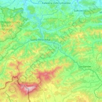
Name: powiat suski topographic map, elevation, terrain.
Location: powiat suski, Lesser Poland Voivodeship, Poland (49.57145 19.36998 49.83155 19.91212)
Average elevation: 1,946 ft
Minimum elevation: 837 ft
Maximum elevation: 5,614 ft
Other topographic maps
Click on a map to view its topography, its elevation and its terrain.
Svinica / Świnica
Poland > Lesser Poland Voivodeship > Tatra County > Brzegi
Average elevation: 6,093 ft
Klein
Poland > Lesser Poland Voivodeship > Oświęcim County > Stawy Monowskie > Zalesie
Average elevation: 741 ft
Podzamcze
Poland > Lesser Poland Voivodeship > Kraków County > Korzkiew > Podzamcze
Average elevation: 1,053 ft
Wielki Giewont
Poland > Lesser Poland Voivodeship > Tatra County > Zakopane
Average elevation: 4,849 ft
Podkościele
Poland > Lesser Poland Voivodeship > Tarnów County > Wola Rzędzińska
Average elevation: 787 ft
Morskie Oko
Poland > Lesser Poland Voivodeship > Tatra County > Brzegi
Morskie Oko at the foothill of Tatra Mountains in southern Poland which average 2,000 metres (6,600 ft) in elevation
Average elevation: 5,738 ft
Święty Krzyż
Poland > Lesser Poland Voivodeship > Nowy Sącz County > Królowa Polska > Góry
Average elevation: 1,519 ft
Tatry
Poland > Lesser Poland Voivodeship > Tatra County > Zakopane
The Tatras lie in the temperate zone of Central Europe. They are an important barrier to the movements of air masses. Their mountainous topography causes one of the most diverse climates in that region.
Average elevation: 5,404 ft