
Mad River topographic map
Interactive map
Click on the map to display elevation.
About this map
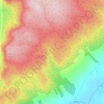
Name: Mad River topographic map, elevation, terrain.
Location: Mad River, County Sligo, Connacht, Ireland (54.09830 -8.80704 54.15209 -8.77408)
Average elevation: 922 ft
Minimum elevation: 187 ft
Maximum elevation: 1,509 ft
Other topographic maps
Click on a map to view its topography, its elevation and its terrain.
Great Skellig
Skellig Michael consists of approximately 22 hectares (54 acres) of rock, with its highest point, known as the Spit, 218 m (714 ft) above sea level. The island is defined by its twin peaks and intervening valley (known as Christ's Saddle), which make its landscape steep and inhospitable. It is best known for…
Average elevation: 3 ft
Bruree
Ireland > County Limerick > The Municipal District of Cappamore — Kilmallock
Average elevation: 203 ft
Broadford
Ireland > County Limerick > The Municipal District of Newcastle West > Broadford
Average elevation: 413 ft
Limerick
Ireland > County Limerick > Limerick
Limerick's climate is classified as temperate oceanic (Köppen Cfb). Met Éireann maintains a climatological weather station at Shannon Airport, 20 kilometres west of the city in County Clare. Shannon Airport records an average of 977 millimetres of precipitation annually, most of which is rain. Limerick has a…
Average elevation: 33 ft