
Mount Fiji topographic map
Interactive map
Click on the map to display elevation.
About this map
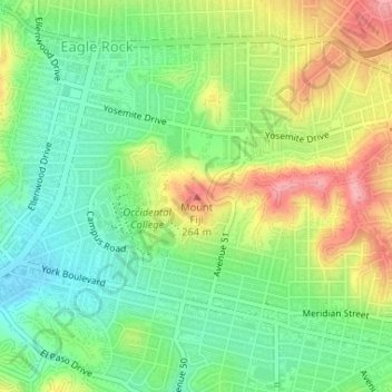
Name: Mount Fiji topographic map, elevation, terrain.
Average elevation: 627 ft
Minimum elevation: 472 ft
Maximum elevation: 853 ft
Los Angeles County trails, hiking, mountain biking, running and outdoor activities
Other topographic maps
Click on a map to view its topography, its elevation and its terrain.
Pacific Palisades
United States > California > Los Angeles County > Los Angeles
Pacific Palisades was formally founded in 1921 by a Methodist organization, and in the years that followed became a refuge for Jewish artists and intellectuals fleeing the Holocaust. The Palisades would later be sought after by celebrities and other high-profile individuals seeking privacy. It is known for its…
Average elevation: 643 ft
Santa Ynez Reservoir
United States > California > Los Angeles County > Los Angeles
Average elevation: 1,007 ft
Arleta Neighborhood Council District
United States > California > Los Angeles County > Los Angeles
Average elevation: 899 ft
Los Angeles City Council District 5
United States > California > Los Angeles County > Los Angeles
Average elevation: 430 ft
West Hills Neighborhood Council District
United States > California > Los Angeles County > Los Angeles
Average elevation: 1,047 ft
Los Angeles City Council District 6
United States > California > Los Angeles County > Los Angeles
Average elevation: 827 ft
Los Angeles City Council District 7
United States > California > Los Angeles County > Los Angeles
Average elevation: 1,680 ft
Hollywood Hills
United States > California > Los Angeles County > Los Angeles
Average elevation: 794 ft
Los Angeles River
United States > California > Los Angeles County > Los Angeles
Average elevation: 797 ft
Runyon Canyon Park
United States > California > Los Angeles County > Los Angeles
Average elevation: 771 ft
Augustus F. Hawkins Natural Park
United States > California > Los Angeles County > Los Angeles
Average elevation: 180 ft
Maguire Gardens
United States > California > Los Angeles County > Los Angeles
Average elevation: 325 ft
Genesee Avenue Park
United States > California > Los Angeles County > Los Angeles
Average elevation: 108 ft
Topanga State Park
United States > California > Los Angeles County > Los Angeles
Average elevation: 1,093 ft