
Town of Red Hook topographic map
Interactive map
Click on the map to display elevation.
About this map
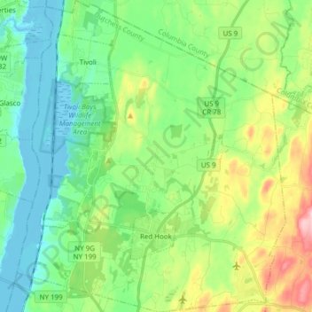
Name: Town of Red Hook topographic map, elevation, terrain.
Location: Town of Red Hook, Dutchess County, New York, United States (41.96730 -73.94383 42.08107 -73.81194)
Average elevation: 203 ft
Minimum elevation: -20 ft
Maximum elevation: 676 ft
Dutchess County trails, hiking, mountain biking, running and outdoor activities
Other topographic maps
Click on a map to view its topography, its elevation and its terrain.
Pecksville
United States > New York > Dutchess County > Town of East Fishkill
Average elevation: 899 ft
Alamar Unit
United States > New York > Dutchess County > Town of East Fishkill
Average elevation: 912 ft
Stissing Mountain Multiple Use Area
United States > New York > Dutchess County > Town of Pine Plains
Average elevation: 712 ft
Drayton Grant Park at Burger Hill
United States > New York > Dutchess County > Town of Rhinebeck
Average elevation: 335 ft
United States of America Property
United States > New York > Dutchess County > Village of Pawling
Average elevation: 823 ft
Annandale-on-Hudson
United States > New York > Dutchess County > Town of Red Hook
Average elevation: 141 ft
Timothy Heights
United States > New York > Dutchess County > Town of Pleasant Valley
Average elevation: 285 ft
Shenandoah
United States > New York > Dutchess County > Town of East Fishkill
Average elevation: 502 ft
Netherwood
United States > New York > Dutchess County > Town of Pleasant Valley
Average elevation: 361 ft
Stormville
United States > New York > Dutchess County > Town of East Fishkill
Average elevation: 367 ft
Mt. Beacon Fire Observation Tower
United States > New York > Dutchess County
Average elevation: 965 ft