
Make a donation
Gear up for your next adventure:
As an Amazon Associate, this site earns from qualifying purchases at no extra cost to you.
Mont-Tremblant topographic map
Click on the map to display elevation.
Make a donation
Gear up for your next adventure:
As an Amazon Associate, this site earns from qualifying purchases at no extra cost to you.
Mont-Tremblant
The city is dominated by Mont Tremblant with an altitude of 968m which is one of the highest peaks in southern Quebec.
Make a donation
Gear up for your next adventure:
As an Amazon Associate, this site earns from qualifying purchases at no extra cost to you.
About this map
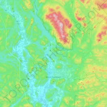
Name: Mont-Tremblant topographic map, elevation, terrain.
Location: Mont-Tremblant, Les Laurentides, Laurentides, Quebec, Canada (46.03810 -74.67667 46.31503 -74.50408)
Average elevation: 1,175 ft
Minimum elevation: 610 ft
Maximum elevation: 3,028 ft
Make a donation
Gear up for your next adventure:
As an Amazon Associate, this site earns from qualifying purchases at no extra cost to you.
Other topographic maps
Click on a map to view its topography, its elevation and its terrain.
Lac de la Poche
Canada > Quebec > Les Laurentides > Mont-Tremblant > Lac-Tremblant-Nord
Average elevation: 981 ft
Lac Swell
Canada > Quebec > Les Laurentides > Sainte-Lucie-des-Laurentides
Average elevation: 1,427 ft
Make a donation
Gear up for your next adventure:
As an Amazon Associate, this site earns from qualifying purchases at no extra cost to you.
Make a donation
Gear up for your next adventure:
As an Amazon Associate, this site earns from qualifying purchases at no extra cost to you.
Make a donation
Gear up for your next adventure:
As an Amazon Associate, this site earns from qualifying purchases at no extra cost to you.
Lac-à-la-Truite
Canada > Quebec > Les Laurentides > Sainte-Agathe-des-Monts
Average elevation: 1,339 ft
Mont Sainte-Agathe
Canada > Quebec > Les Laurentides > Sainte-Agathe-des-Monts
Average elevation: 1,470 ft
Make a donation
Gear up for your next adventure:
As an Amazon Associate, this site earns from qualifying purchases at no extra cost to you.
Make a donation
Gear up for your next adventure:
As an Amazon Associate, this site earns from qualifying purchases at no extra cost to you.