
Make a donation
Gear up for your next adventure:
As an Amazon Associate, this site earns from qualifying purchases at no extra cost to you.
Lourdes topographic map
Click on the map to display elevation.
Make a donation
Gear up for your next adventure:
As an Amazon Associate, this site earns from qualifying purchases at no extra cost to you.
Lourdes
Lourdes lies at an elevation of 420 m (1,380 ft) and in a central position through which runs the fast-flowing river Gave de Pau from the south, coming from its source at Gavarnie; into it flow several smaller rivers from Barèges and Cauterets. The Gave then branches off to the west towards the Béarn, running past the banks of the Grotto and on downstream to Pau and then Biarritz.
Make a donation
Gear up for your next adventure:
As an Amazon Associate, this site earns from qualifying purchases at no extra cost to you.
About this map
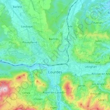
Name: Lourdes topographic map, elevation, terrain.
Average elevation: 1,686 ft
Minimum elevation: 1,175 ft
Maximum elevation: 3,550 ft
Make a donation
Gear up for your next adventure:
As an Amazon Associate, this site earns from qualifying purchases at no extra cost to you.
Other topographic maps
Click on a map to view its topography, its elevation and its terrain.
Cirque de Gavarnie
France > Occitania > Hautes Pyrenees > Gavarnie-Gèdre > Gavarnie
Average elevation: 7,756 ft
Make a donation
Gear up for your next adventure:
As an Amazon Associate, this site earns from qualifying purchases at no extra cost to you.
Hôtellerie du Cirque
France > Occitania > Hautes Pyrenees > Gavarnie-Gèdre > Gavarnie
Average elevation: 6,526 ft
Lac de Gaube
France > Occitania > Hautes Pyrenees > Cauterets
The lake is situated in an altitude of 1725 m, an egg-shaped form stretching itself along a north–south axis in the valley of Gaube. This steep-sided valley is located at the foot of the Vignemale (3298M). The lake is surrounded by the peak Mayouret (2688 m) to the east, the big Peak of the Paloumères (2720…
Average elevation: 6,821 ft
Make a donation
Gear up for your next adventure:
As an Amazon Associate, this site earns from qualifying purchases at no extra cost to you.
Vue sur Cascades et Pont d'Espagne
France > Occitania > Hautes Pyrenees > Cauterets
Average elevation: 5,994 ft
Pierrefitte-Nestalas
France > Occitania > Hautes Pyrenees > Pierrefitte-Nestalas > Pierrefitte-Nestalas
Average elevation: 2,336 ft
Make a donation
Gear up for your next adventure:
As an Amazon Associate, this site earns from qualifying purchases at no extra cost to you.
Cirque de Gavarnie
France > Occitania > Hautes Pyrenees > Gavarnie-Gèdre > Gavarnie
Average elevation: 7,756 ft
Make a donation
Gear up for your next adventure:
As an Amazon Associate, this site earns from qualifying purchases at no extra cost to you.
Make a donation
Gear up for your next adventure:
As an Amazon Associate, this site earns from qualifying purchases at no extra cost to you.